|
search place name
|
||
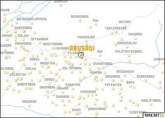
Abū Sa‘dī (Khorāsān, Iran)Abū Sa‘dī is a town in the Khorāsān region of Iran. An overview map of the region around Abū Sa‘dī is displayed below.
regional and 3d topo map of Abū Sa‘dī, Iran ::
Abū Sa‘dī airports ::
The nearest airport is ASB - Ashkhabad Ashgabat, located 206.2 km north of Abū Sa‘dī.
Nearby towns ::
Abbāsābād (0.5km east) //
Khorramābād (1.2km south) //
Tūrānī (1.3km south) //
Fīlkhāneh (1.3km west) //
Ḩoseynābād-e Nāz̧er (1.8km south east) //
Sheykhlān (2.2km south west) //
Feyẕābād-e Gonghā (2.2km south west) //
Sa‘dābād (2.2km west) //
Shāhābād-e Mashāyekh (2.2km west) //
Feyẕābād-e Gonghā (2.5km south west) //
Mowlūq (2.7km south east) //
Kheyrābād (2.8km south east) //
Ma'vá (3.0km south) //
Dehnow (2.6km south west) //
Sheykhlān (2.7km south west) //
Shāh Faẕl (2.8km west) //
Ḩamīdābād (3.5km north) //
Torbābād (2.9km west) //
Solţānābād (3.5km south west) //
Lak Lak Āshīān (3.2km west) //
Khowsh-e Bālā (3.3km west) //
Adk (3.3km east) //
Fūshenjān (4.1km north) //
Bornāābād (4.2km south) //
Najmābād (3.6km south east) //
‘Eynābād (3.7km north west) //
Taqīābād-e Qavām (3.7km north west) //
Boshrūy (4.6km south) //
Aḩmadābād (4.6km south) //
[all distances 'as the bird flies' and approximate]  Places with similar names to Abū Sa‘dī, Iran ::
// Abū Saddah (IQ)
// Abū Şaydah (IQ)
// Abū Zayd (IQ)
// Abistu (EG)
// Aybastı (TR)
// Aybastı (TR)
// Abesedo (ES)
// Abū Zayd (SD)
// Abu Saīd (PK)
// Abū as Sayyid (SY)
Disclaimer :: Information on this page comes without warranty of any kind |
||
|
Where is Abū Sa‘dī? Elevation and coordinates ::
Latitude (lat): 36°10'38"N Longitude (lon): 58°53'14"E
Elevation (approx.): 1226m (map arrows pan, magnifying glasses zoom) |
||
|
Visiting Abū Sa‘dī? Hotel/Accommodation ::
Book a hotel in Abū Sa‘dī Travel Guide ::
Buy a travel guide for Iran rental cars ::
car rental offers GPS waypoint ::
download a GPX waypoint (PoI) of Abū Sa‘dī for your GPS receiver
|
||