|
search place name
|
||
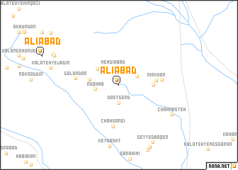
‘Alīābād (Khorāsān, Iran)‘Alīābād is a town in the Khorāsān region of Iran. An overview map of the region around ‘Alīābād is displayed below.
regional and 3d topo map of ‘Alīābād, Iran ::
‘Alīābād airports ::
The nearest airport is XBJ - Birjand, located 70.7 km north west of ‘Alīābād.
Nearby towns ::
Ginakeh (0.3km north west) //
Mehdīābād (2.8km north) //
Ḩoseynābād (2.8km north) //
Dastgerd (2.9km south) //
Neyāb (2.8km north east) //
Nūqhāb (3.2km west) //
Neyk (3.7km north west) //
Cheshmeh Kūshk (4.0km west) //
Zobeydeh (4.6km east) //
Mīghān (5.0km east) //
Mīr Khān (5.1km east) //
Chāh Sangī (6.6km south) //
Būābād (5.8km east) //
Golandar (5.9km west) //
Chāh Rāsteh (8.5km south east) //
[all distances 'as the bird flies' and approximate] 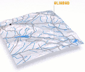 Places with similar names to ‘Alīābād, Iran ::
Disclaimer :: Information on this page comes without warranty of any kind |
||
|
Where is ‘Alīābād? Elevation and coordinates ::
Latitude (lat): 32°23'33"N Longitude (lon): 59°43'30"E
Elevation (approx.): 1945m (map arrows pan, magnifying glasses zoom) |
||
|
Visiting ‘Alīābād? Hotel/Accommodation ::
Book a hotel in ‘Alīābād Travel Guide ::
Buy a travel guide for Iran rental cars ::
car rental offers GPS waypoint ::
download a GPX waypoint (PoI) of ‘Alīābād for your GPS receiver
|
||