|
search place name
|
||
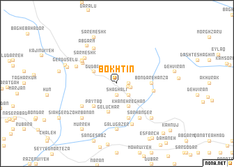
Bokhtīn (Kermān, Iran)Bokhtīn is a town in the Kermān region of Iran. An overview map of the region around Bokhtīn is displayed below.
regional and 3d topo map of Bokhtīn, Iran ::
Bokhtīn airports ::
The nearest airport is KER - Kerman, located 106.1 km north of Bokhtīn.
Nearby towns ::
Darreh Bīd (1.6km east) //
Sang Sīāh (1.9km south) //
Shaghālī (1.9km south) //
Poshteh Zong (1.9km north) //
Khoshkeh Rūd (1.6km east) //
Zonk (2.1km east) //
Bāghū (2.5km south east) //
Gudki (2.5km north west) //
Gudbān (3.7km north west) //
Khāneh Reghān (4.0km south east) //
Gelūchār (4.8km south) //
Pāyţāq (4.9km south west) //
Bondar-e Hanzā (4.8km east) //
Qalandarān (5.8km south) //
Hanzā (5.3km east) //
Esfenā (5.7km north west) //
Eshkanūʼīyeh (6.0km north west) //
Sar Meshk (6.1km north west) //
Ghusichār (6.1km south west) //
Gan Gāv (6.4km north west) //
Sarhanger (6.4km south east) //
Darreh Rūd (6.4km south east) //
Āl Ghīās̄ī (6.1km north west) //
Gond-e Gāv (6.2km north west) //
Eshkanū'īyeh (6.9km south) //
Galū Gāzer (7.4km south) //
Āb Garm (7.3km north west) //
Z̧ohrbanān (7.4km south west) //
Kūh-e Now (7.4km south east) //
[all distances 'as the bird flies' and approximate] 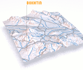 Places with similar names to Bokhtīn, Iran ::
Disclaimer :: Information on this page comes without warranty of any kind |
||
|
Where is Bokhtīn? Elevation and coordinates ::
Latitude (lat): 29°20'0"N Longitude (lon): 57°9'0"E
Elevation (approx.): 2819m (map arrows pan, magnifying glasses zoom) |
||
|
Visiting Bokhtīn? Hotel/Accommodation ::
Book a hotel in Bokhtīn Travel Guide ::
Buy a travel guide for Iran rental cars ::
car rental offers GPS waypoint ::
download a GPX waypoint (PoI) of Bokhtīn for your GPS receiver
|
||