|
search place name
|
||
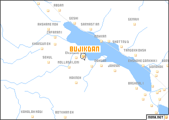
Būjīkdān (Ostān-e Būshehr, Iran)Būjīkdān is a town in the Ostān-e Būshehr region of Iran. An overview map of the region around Būjīkdān is displayed below.
regional and 3d topo map of Būjīkdān, Iran ::
Būjīkdān airports ::
The nearest airport is BUZ - Bushehr, located 143.9 km north west of Būjīkdān.
Other airports nearby include SYZ - Shiraz Shahid Dastghaib Intl (188.7 km north east), BAH - Bahrain Intl (222.6 km south west), DHA - Dhahran King Abdulaziz Ab (251.5 km south west), Nearby towns ::
Eḩshām-e Now (1.7km west) //
Tol-e Sang (2.0km south east) //
Mollā Sālemī (3.5km south west) //
Rāhdār (3.5km east) //
Makneh (5.3km south) //
Nowkan (5.3km north east) //
Lūhak (6.4km north east) //
Sar Mastān (7.0km north) //
Jamrak (6.4km east) //
Now Kahand (6.8km north west) //
Sehūl (7.1km west) //
Za‘farānī (7.6km north west) //
Geshī (8.4km north) //
Shaţţ Rūd (7.8km east) //
Aḩshām-e Now (9.8km north west) //
[all distances 'as the bird flies' and approximate] 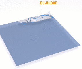 Places with similar names to Būjīkdān, Iran ::
// Boju-Cătun (RO)
// Būjīkdān (IR)
Disclaimer :: Information on this page comes without warranty of any kind |
||
|
Where is Būjīkdān? Elevation and coordinates ::
Latitude (lat): 27°58'43"N Longitude (lon): 51°49'0"E
Elevation (approx.): 24m (map arrows pan, magnifying glasses zoom) |
||
|
Visiting Būjīkdān? Hotel/Accommodation ::
Book a hotel in Būjīkdān Travel Guide ::
Buy a travel guide for Iran rental cars ::
car rental offers GPS waypoint ::
download a GPX waypoint (PoI) of Būjīkdān for your GPS receiver
|
||