|
search place name
|
||
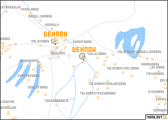
Deh Now (Kermān, Iran)Deh Now is a town in the Kermān region of Iran. An overview map of the region around Deh Now is displayed below.
regional and 3d topo map of Deh Now, Iran ::
Deh Now airports ::
The nearest airport is KER - Kerman, located 51.5 km north east of Deh Now.
Nearby towns ::
Bahādābād (0.4km south west) //
Āteshān (1.9km north) //
Mobārakeh (1.9km north east) //
Jalālābād (2.5km south west) //
‘Alīābād (2.7km north west) //
Jalālābād (2.7km east) //
Sharīfābād (3.2km north) //
Nāşerābād (3.1km north east) //
Ḩanafīyeh (3.1km west) //
Tolombeh-ye Doktor Khāleqī (3.8km south east) //
Tolombeh-ye Z̄āferī (4.0km east) //
Tolombeh-ye Kalāntārī (4.5km south east) //
Dashtkār (4.1km east) //
Tolombeh-ye Malek Manşūr (4.8km south) //
Jūshūr-e Pā'īn (4.6km north west) //
Ḩeydarābād (4.5km east) //
Bardsīr (4.9km north west) //
Behjerd (5.0km west) //
Torābābād (5.8km north west) //
Şaḩrāgāh (5.9km north west) //
Şāremābād (5.9km north west) //
Ţāherābād (5.9km north west) //
Ne‘matābād (5.7km east) //
Sal Bard (6.0km north west) //
Karīmābād (6.0km north west) //
Moselābād (6.0km north west) //
Tolombeh-ye Asadābād (6.0km east) //
Fakhrābād-e Pā'īn (6.3km north west) //
Tārābād (6.7km north west) //
[all distances 'as the bird flies' and approximate] 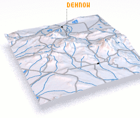 Places with similar names to Deh Now, Iran ::
Disclaimer :: Information on this page comes without warranty of any kind |
||
|
Where is Deh Now? Elevation and coordinates ::
Latitude (lat): 29°54'30"N Longitude (lon): 56°37'17"E
Elevation (approx.): 2071m (map arrows pan, magnifying glasses zoom) |
||
|
Visiting Deh Now? Hotel/Accommodation ::
Book a hotel in Deh Now Travel Guide ::
Buy a travel guide for Iran rental cars ::
car rental offers GPS waypoint ::
download a GPX waypoint (PoI) of Deh Now for your GPS receiver
|
||