|
search place name
|
||
Deh Now-e Pā'īn (Kermān, Iran)Deh Now-e Pā'īn is a town in the Kermān region of Iran. An overview map of the region around Deh Now-e Pā'īn is displayed below.
regional and 3d topo map of Deh Now-e Pā'īn, Iran ::

Deh Now-e Pā'īn airports ::
The nearest airport is KER - Kerman, located 163.2 km north east of Deh Now-e Pā'īn.
Nearby towns ::
Deh Now-e Bālā (1.0km north) //
Dowlatābād (1.3km south) //
Ja‘farābād (2.0km north) //
Moḩammadābād-e Qolī (2.4km north) //
Mollā Ḩājjī (2.9km south) //
Ebrāhīmābād-e Zardū'īyeh (3.1km south east) //
Raḩīmābād (3.5km north) //
Ne‘matābād (4.1km north) //
Abbāsābād (3.9km east) //
Dārābābād (4.8km north) //
Ḩosnī (4.8km north) //
‘Abbāsābād (4.4km east) //
Tolombeh-ye Gholāmḩoseyn-e Shahābī (4.6km south east) //
Manşūrābād (4.4km east) //
Ḩoseynābād (5.5km north) //
Ḩasanābād (5.7km north) //
Moḩammadābād-e Darvīsh (5.1km east) //
Ḩāfez̧ābād (5.9km south east) //
Ḩāfez̧ābād (6.0km south east) //
Tolombeh-ye Ne‘matābād (6.0km south east) //
Tolombeh-ye Solţānī (6.1km south east) //
Dowlatābād (5.9km south east) //
Ne‘matābād-e Farrokh (6.7km south) //
Ḩoseynābād (6.9km north) //
Akbarābād (6.1km north east) //
Deh Mīr (6.9km north) //
Tolombeh-ye Sarhang Vaḩīd (7.1km north east) //
Ḩājjīābād (7.1km south east) //
Zeydābād (7.2km north east) //
[all distances 'as the bird flies' and approximate] 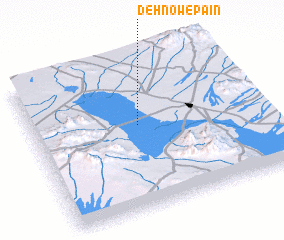 Places with similar names to Deh Now-e Pā'īn, Iran :: Disclaimer :: Information on this page comes without warranty of any kind |
||
|
Where is Deh Now-e Pā'īn? Elevation and coordinates ::
Latitude (lat): 29°33'55"N Longitude (lon): 55°28'11"E
Elevation (approx.): 1704m (map arrows pan, magnifying glasses zoom) |
||
|
Visiting Deh Now-e Pā'īn? Hotel/Accommodation ::
Book a hotel in Deh Now-e Pā'īn Travel Guide ::
Buy a travel guide for Iran rental cars ::
car rental offers GPS waypoint ::
download a GPX waypoint (PoI) of Deh Now-e Pā'īn for your GPS receiver
|
||