|
search place name
|
||
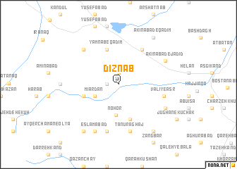
Dīznāb (Kermān, Iran)Dīznāb is a town in the Kermān region of Iran. An overview map of the region around Dīznāb is displayed below.
regional and 3d topo map of Dīznāb, Iran ::
Dīznāb airports ::
The nearest airport is TBZ - Tabriz Intl, located 52.7 km north west of Dīznāb.
Nearby towns ::
Sarān (1.5km west) //
Kargān-e Qadīm (1.9km north) //
Mīārdān (3.5km south west) //
Nohor (4.9km south) //
Galah Khāneh (4.8km south west) //
Jūghān-e Bozorg (5.7km south) //
Yamnab-e Qadīm (5.7km north) //
Īmanāb-e Qadīm (5.7km north) //
Kargān-e Jadīd (6.3km north east) //
Valī-ye ‘Aşr (6.0km east) //
Tanūr Āghāj (7.6km south) //
Ḩeşār (7.6km south) //
Esfangareh (7.1km north west) //
Eslāmābād (8.0km south) //
Bāshsīz Ūjān (6.9km south east) //
Akīnābād-e Jadīd (6.9km north east) //
Arqaneh (8.6km south east) //
Asbābād (8.6km south east) //
Khātūnābād (8.6km south west) //
Akīnābād-e Qadīm (8.6km north east) //
[all distances 'as the bird flies' and approximate]  Places with similar names to Dīznāb, Iran ::
// Tseneb (RU)
// Tisanabo (CD)
// Dusun B (ID)
// Ðà Sơn (1) (VN)
// Tú Sơn (1) (VN)
// Disanbao (CN)
// Disanbu (CN)
Disclaimer :: Information on this page comes without warranty of any kind |
||
|
Where is Dīznāb? Elevation and coordinates ::
Latitude (lat): 37°50'0"N Longitude (lon): 46°42'0"E
Elevation (approx.): 1934m (map arrows pan, magnifying glasses zoom) |
||
|
Visiting Dīznāb? Hotel/Accommodation ::
Book a hotel in Dīznāb Travel Guide ::
Buy a travel guide for Iran rental cars ::
car rental offers GPS waypoint ::
download a GPX waypoint (PoI) of Dīznāb for your GPS receiver
|
||