|
search place name
|
||
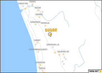
Dū Dar (Hormozgān, Iran)Dū Dar is a town in the Hormozgān region of Iran. An overview map of the region around Dū Dar is displayed below.
regional and 3d topo map of Dū Dar, Iran ::
Dū Dar airports ::
The nearest airport is BND - Bandar Abbass Intl, located 93.5 km north west of Dū Dar.
Other airports nearby include KHS - Khasab (105.8 km south west), RKT - Ras Al Khaimah Intl (169.0 km south west), FJR - Fujeirah Fujairah Intl (193.5 km south west), SHJ - Sharjah Intl (221.3 km south west), Nearby towns ::
Zamīn-e Mollā (3.9km south) //
Konārjū (4.4km north west) //
Zīārat (5.0km south west) //
Band-e Gormān (6.0km south) //
Chahār Borjī (5.8km south west) //
Shāh Mardī (6.7km north west) //
Ḩasanābād-e Zīārat (7.0km south west) //
Gandomī (7.2km south) //
Dojembīlān (7.6km south east) //
Karpān (8.2km north west) //
Hamzāng (8.8km south east) //
Khargūshī (9.6km south east) //
[all distances 'as the bird flies' and approximate] 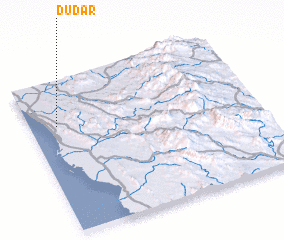 Places with similar names to Dū Dar, Iran ::
Disclaimer :: Information on this page comes without warranty of any kind |
||
|
Where is Dū Dar? Elevation and coordinates ::
Latitude (lat): 26°42'7"N Longitude (lon): 57°7'22"E
Elevation (approx.): 73m (map arrows pan, magnifying glasses zoom) |
||
|
Visiting Dū Dar? Hotel/Accommodation ::
Book a hotel in Dū Dar Travel Guide ::
Buy a travel guide for Iran rental cars ::
car rental offers GPS waypoint ::
download a GPX waypoint (PoI) of Dū Dar for your GPS receiver
|
||