|
search place name
|
||
Dūlābād (Khorāsān, Iran)Dūlābād is a town in the Khorāsān region of Iran. An overview map of the region around Dūlābād is displayed below.
regional and 3d topo map of Dūlābād, Iran ::
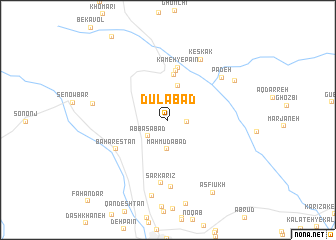
Nearby towns ::
Dowlatābād (1.8km east) //
‘Abbāsābād (2.6km south west) //
Maḩmūdābād (3.3km south) //
Qal‘eh Now (3.9km north) //
Godār Peydar (5.1km north) //
‘Abdolābād (5.5km north) //
Kāmeh-ye Pā'īn (5.9km north) //
Bahārestān (5.8km south west) //
Sar Kārīz (7.1km south) //
Dūgheshk (7.5km south) //
Padeh (6.8km north east) //
Keskak (7.4km north east) //
Senjed Būr (7.1km west) //
Serīshāh (7.5km north east) //
Ẕīā od Dīn-e Bālā (8.6km south) //
Asfīūkh (9.1km south east) //
[all distances 'as the bird flies' and approximate] 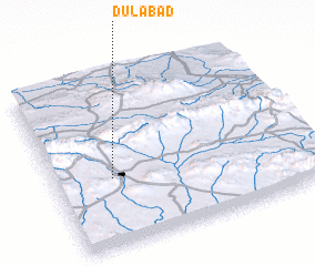 Places with similar names to Dūlābād, Iran ::
// Talbott (US)
// Talbot (US)
// Dealu Botii (RO)
// Tall Abţaḩ (IQ)
// Delābād (IR)
// Delīābād (IR)
// Dīālābād (IR)
// Dūlbīd (IR)
// Talbot (US)
// Talbot (US)
Disclaimer :: Information on this page comes without warranty of any kind |
||
|
Where is Dūlābād? Elevation and coordinates ::
Latitude (lat): 35°24'8"N Longitude (lon): 59°13'35"E
Elevation (approx.): 1625m (map arrows pan, magnifying glasses zoom) |
||
|
Visiting Dūlābād? Hotel/Accommodation ::
Book a hotel in Dūlābād Travel Guide ::
Buy a travel guide for Iran rental cars ::
car rental offers GPS waypoint ::
download a GPX waypoint (PoI) of Dūlābād for your GPS receiver
|
||