|
search place name
|
||
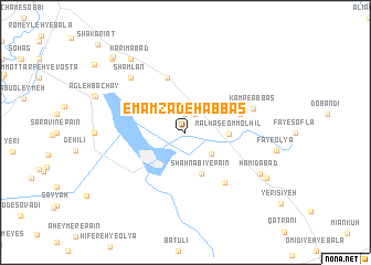
Emāmzādeh ‘Abbās (Khūzestān, Iran)Emāmzādeh ‘Abbās is a town in the Khūzestān region of Iran. An overview map of the region around Emāmzādeh ‘Abbās is displayed below.
regional and 3d topo map of Emāmzādeh ‘Abbās, Iran ::
Emāmzādeh ‘Abbās airports ::
The nearest airport is MRX - Bandar Mahshahr Mahshahr, located 55.0 km south west of Emāmzādeh ‘Abbās.
Other airports nearby include AWZ - Ahwaz (93.1 km north west), QMJ - Masjed Soleiman Shahid Asyaee (127.6 km north), ABD - Abadan (141.8 km south west), BSR - Basrah Intl (187.7 km west), Nearby towns ::
Molḩeh-ye ‘Olyā (1.9km north) //
Molḩeh-ye Soflá (2.0km north east) //
Shāh Nabī-ye ‘Olyā (3.1km south east) //
Malḩas-e Omm ol Ḩīl (3.8km east) //
Shāh Nabī-ye Pā'īn (4.5km south) //
Molḩeh-ye Vostá (5.8km north) //
‘Abbas Kamp (5.1km east) //
Obūdehālīs (6.1km south east) //
Kamp-e ‘Abbās (6.3km east) //
Shamlān (7.3km north west) //
Ḩamīdābād (7.7km south east) //
Eslāmābād (8.8km north west) //
Karīmābād (8.8km north west) //
Şāleḩābād (8.4km south east) //
Jāberābād (9.8km north west) //
Salāmābād (9.9km north west) //
Shakarīāt (11.7km north west) //
[all distances 'as the bird flies' and approximate] 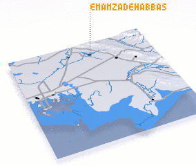 Places with similar names to Emāmzādeh ‘Abbās, Iran ::
Disclaimer :: Information on this page comes without warranty of any kind |
||
|
Where is Emāmzādeh ‘Abbās? Elevation and coordinates ::
Latitude (lat): 30°53'0"N Longitude (lon): 49°35'0"E
Elevation (approx.): 27m (map arrows pan, magnifying glasses zoom) |
||
|
Visiting Emāmzādeh ‘Abbās? Hotel/Accommodation ::
Book a hotel in Emāmzādeh ‘Abbās Travel Guide ::
Buy a travel guide for Iran rental cars ::
car rental offers GPS waypoint ::
download a GPX waypoint (PoI) of Emāmzādeh ‘Abbās for your GPS receiver
|
||