|
search place name
|
||
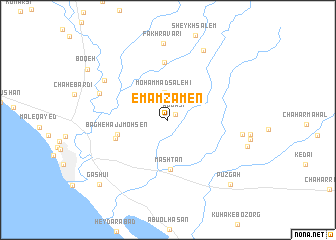
Emām Ẕāmen (Ostān-e Būshehr, Iran)Emām Ẕāmen is a town in the Ostān-e Būshehr region of Iran. An overview map of the region around Emām Ẕāmen is displayed below.
regional and 3d topo map of Emām Ẕāmen, Iran ::
Emām Ẕāmen airports ::
The nearest airport is BUZ - Bushehr, located 77.3 km south of Emām Ẕāmen.
Other airports nearby include MRX - Bandar Mahshahr Mahshahr (175.6 km north west), SYZ - Shiraz Shahid Dastghaib Intl (191.3 km east), AWZ - Ahwaz (261.1 km north west), Nearby towns ::
‘Abbāsī (1.0km north east) //
Moḩammad Şāleḩī (3.1km north) //
Mashtān (5.5km south) //
Bāgh-e Ḩājj Moḩsen (5.2km west) //
Qal‘eh-ye Seyyed (5.5km west) //
Bāgh-e Seyyed Gholām Ḩasan (6.5km north) //
Cham-e Shahāb (7.3km north west) //
Tol-e Tall (7.6km north west) //
Gāv Sefīd-e Shomālī (7.4km east) //
Fakhr Āvarī (8.5km north) //
Gomārūn (8.5km north east) //
Pūzgāh (9.4km south east) //
Gashū'ī (9.8km south west) //
[all distances 'as the bird flies' and approximate]  Places with similar names to Emām Ẕāmen, Iran ::
// Emām Zamīn (IR)
Disclaimer :: Information on this page comes without warranty of any kind |
||
|
Where is Emām Ẕāmen? Elevation and coordinates ::
Latitude (lat): 29°36'56"N Longitude (lon): 50°37'1"E
Elevation (approx.): 14m (map arrows pan, magnifying glasses zoom) |
||
|
Visiting Emām Ẕāmen? Hotel/Accommodation ::
Book a hotel in Emām Ẕāmen Travel Guide ::
Buy a travel guide for Iran rental cars ::
car rental offers GPS waypoint ::
download a GPX waypoint (PoI) of Emām Ẕāmen for your GPS receiver
|
||