|
search place name
|
||
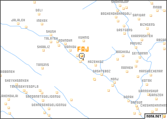
Fāj (Chahār Maḩāll va Bakhtīār, Iran)Fāj is a town in the Chahār Maḩāll va Bakhtīār region of Iran. An overview map of the region around Fāj is displayed below.
regional and 3d topo map of Fāj, Iran ::
Fāj airports ::
The nearest airport is QMJ - Masjed Soleiman Shahid Asyaee, located 190.9 km north west of Fāj.
Other airports nearby include MRX - Bandar Mahshahr Mahshahr (195.0 km west), SYZ - Shiraz Shahid Dastghaib Intl (236.2 km south east), Nearby towns ::
Ghāch (0.1km south west) //
Dehkadeh (0.8km south west) //
Dūrak-e Ghāch (1.4km north west) //
Māzeh Kaz (2.7km south east) //
Varkow (3.2km north west) //
Kūh Rīg (4.1km north) //
Dar Kalāt-e Maḩmūd (4.9km south east) //
Mownowm (4.8km north west) //
Emāmzādeh Maḩmūdī (5.1km south east) //
Dasht-e Boz (5.0km south east) //
Talāyeh (5.6km north west) //
Ātashgāh (6.3km north west) //
Deh Kohneh (6.6km east) //
Ţalāyeh (7.3km north west) //
Monj (8.0km south east) //
Deh-e Pā'īn (8.2km south east) //
Pareshkaft (8.5km south east) //
Shūsh (8.3km north west) //
Cheshmeh Rīzak-e Shablīz (9.0km south west) //
Monādejān (10.9km north east) //
[all distances 'as the bird flies' and approximate]  Places with similar names to Fāj, Iran ::
Disclaimer :: Information on this page comes without warranty of any kind |
||
|
Where is Fāj? Elevation and coordinates ::
Latitude (lat): 31°12'0"N Longitude (lon): 51°3'0"E
Elevation (approx.): 1623m (map arrows pan, magnifying glasses zoom) |
||
|
Visiting Fāj? Hotel/Accommodation ::
Book a hotel in Fāj Travel Guide ::
Buy a travel guide for Iran rental cars ::
car rental offers GPS waypoint ::
download a GPX waypoint (PoI) of Fāj for your GPS receiver
|
||