|
search place name
|
||
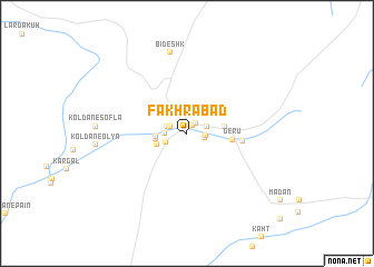
Fakhrābād (Kermān, Iran)Fakhrābād is a town in the Kermān region of Iran. An overview map of the region around Fakhrābād is displayed below.
regional and 3d topo map of Fakhrābād, Iran ::
Fakhrābād airports ::
The nearest airport is KER - Kerman, located 173.0 km north of Fakhrābād.
Other airports nearby include BND - Bandar Abbass Intl (178.5 km south), Nearby towns ::
Meydān (0.7km north) //
Bāgh Tarī (0.7km north) //
Sārīkhānī (0.9km north east) //
Sefteh (1.2km north east) //
Aḩmad Khānī (1.6km east) //
Qanbarī (1.7km north west) //
Khārdān (1.7km north west) //
Tall-e Kūshk (1.7km north west) //
Pīchgāh (1.7km east) //
Bāgh Pīshgāh (1.9km east) //
Bāgh Zāl (1.9km west) //
Āb Bād-e Qahremānī (2.0km west) //
Jārūb (2.1km south west) //
Āb Bād-e Sīvandī (2.8km west) //
Āb Bād-e Pedarī (2.8km west) //
Dīkhū'īyeh (2.9km south west) //
Bāgh Kenār (3.4km east) //
Gerū (4.1km east) //
Khabar (4.9km east) //
Bīdeshk (8.3km north) //
[all distances 'as the bird flies' and approximate] 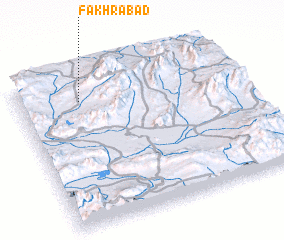 Places with similar names to Fakhrābād, Iran ::
Disclaimer :: Information on this page comes without warranty of any kind |
||
|
Where is Fakhrābād? Elevation and coordinates ::
Latitude (lat): 28°49'37"N Longitude (lon): 56°16'56"E
Elevation (approx.): 1907m (map arrows pan, magnifying glasses zoom) |
||
|
Visiting Fakhrābād? Hotel/Accommodation ::
Book a hotel in Fakhrābād Travel Guide ::
Buy a travel guide for Iran rental cars ::
car rental offers GPS waypoint ::
download a GPX waypoint (PoI) of Fakhrābād for your GPS receiver
|
||