|
search place name
|
||
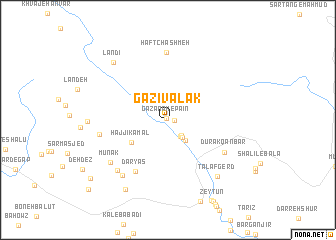
Gāzīvalak (Chahār Maḩāll va Bakhtīār, Iran)Gāzīvalak is a town in the Chahār Maḩāll va Bakhtīār region of Iran. An overview map of the region around Gāzīvalak is displayed below.
regional and 3d topo map of Gāzīvalak, Iran ::
Gāzīvalak airports ::
The nearest airport is QMJ - Masjed Soleiman Shahid Asyaee, located 106.6 km west of Gāzīvalak.
Other airports nearby include AWZ - Ahwaz (160.2 km west), MRX - Bandar Mahshahr Mahshahr (178.6 km south west), Nearby towns ::
Gazanak-e Pā'īn (0.2km north west) //
Kūzalak (0.6km east) //
Deh-e Kal (2.1km south east) //
Būstān (2.2km south east) //
Pātūf (2.4km south east) //
Gazanak-e Bālā (2.6km north west) //
Chand Deh (2.9km south east) //
Ḩājjī Kamāl (4.3km south west) //
Daryās (6.5km south west) //
Dūrak Qanbar (6.5km south east) //
Haft Chashmeh (7.5km north) //
Lah Bīd (6.7km west) //
Gardesh (7.4km south west) //
Mūnak (7.2km south west) //
Morvārīd (7.5km south west) //
Talaf Gerd (7.9km south east) //
Landī (8.2km north west) //
Āb Sūrākh (8.7km south west) //
Qal‘ehcheh-yeMūzarm (9.8km south west) //
Sartol (10.8km south west) //
[all distances 'as the bird flies' and approximate]  Places with similar names to Gāzīvalak, Iran ::
// Casa Fallico (IT)
Disclaimer :: Information on this page comes without warranty of any kind |
||
|
Where is Gāzīvalak? Elevation and coordinates ::
Latitude (lat): 31°46'56"N Longitude (lon): 50°22'4"E
Elevation (approx.): 1125m (map arrows pan, magnifying glasses zoom) |
||
|
Visiting Gāzīvalak? Hotel/Accommodation ::
Book a hotel in Gāzīvalak Travel Guide ::
Buy a travel guide for Iran rental cars ::
car rental offers GPS waypoint ::
download a GPX waypoint (PoI) of Gāzīvalak for your GPS receiver
|
||