|
search place name
|
||
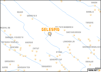
Gel Espīd (Ostān-e Kohgīlūyeh va Būyer Aḩmad, Iran)Gel Espīd is a town in the Ostān-e Kohgīlūyeh va Būyer Aḩmad region of Iran. An overview map of the region around Gel Espīd is displayed below.
regional and 3d topo map of Gel Espīd, Iran ::
Gel Espīd airports ::
The nearest airport is MRX - Bandar Mahshahr Mahshahr, located 173.9 km west of Gel Espīd.
Other airports nearby include QMJ - Masjed Soleiman Shahid Asyaee (176.3 km north west), SYZ - Shiraz Shahid Dastghaib Intl (245.4 km south east), Nearby towns ::
Meleh-ye Bīābāneh (5.0km north east) //
Bar Āftāb-e Tīyak (7.3km south) //
Javakār (6.9km south east) //
Lah-e Mowlā'ī (6.8km south east) //
Zīr Tūt (7.2km south west) //
Eymūk (7.7km south east) //
Tang-e Ālak (7.8km south) //
Khersīn (7.5km south west) //
Chahār Morūn (7.9km south east) //
Tang-e Nākamīn (8.0km south west) //
Sheykh Sarkeh (7.5km east) //
Lamāb (8.7km south west) //
Damreyen (8.7km north west) //
Talkheh Dūn (8.9km south east) //
Āb Chendār-e Gelāl (9.9km south west) //
Āb Sardān-e ‘Olyā (10.8km south east) //
[all distances 'as the bird flies' and approximate]  Places with similar names to Gel Espīd, Iran :: Disclaimer :: Information on this page comes without warranty of any kind |
||
|
Where is Gel Espīd? Elevation and coordinates ::
Latitude (lat): 31°8'49"N Longitude (lon): 50°50'9"E
Elevation (approx.): 2225m (map arrows pan, magnifying glasses zoom) |
||
|
Visiting Gel Espīd? Hotel/Accommodation ::
Book a hotel in Gel Espīd Travel Guide ::
Buy a travel guide for Iran rental cars ::
car rental offers GPS waypoint ::
download a GPX waypoint (PoI) of Gel Espīd for your GPS receiver
|
||