|
search place name
|
||
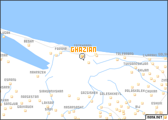
Ghāzīān (Gīlān, Iran)Ghāzīān is a town in the Gīlān region of Iran. An overview map of the region around Ghāzīān is displayed below.
regional and 3d topo map of Ghāzīān, Iran ::
Ghāzīān airports ::
The nearest airport is RAS - Rasht, located 17.6 km south east of Ghāzīān.
Other airports nearby include RZR - Ramsar (121.8 km south east), THR - Teheran Mehrabad Intl (255.0 km south east), Nearby towns ::
Sū Sar (1.0km south east) //
Tāzehābād (2.3km north) //
Khūlak (2.3km north east) //
Shāhver (2.5km north east) //
Shālīver (2.5km north east) //
Bandar-e Anzalī (3.0km north west) //
Fārīvīr (4.4km west) //
Navīr (5.0km west) //
Torobgūdeh (5.9km east) //
Kolūr (6.1km west) //
Gāzgīsheh (8.2km south) //
Hendūkhāleh (8.4km south) //
Şūfīān Deh (8.7km south) //
Gālesh Kheyl (9.7km south east) //
Sīāh Darvīshān (9.8km south west) //
[all distances 'as the bird flies' and approximate]  Places with similar names to Ghāzīān, Iran ::
Disclaimer :: Information on this page comes without warranty of any kind |
||
|
Where is Ghāzīān? Elevation and coordinates ::
Latitude (lat): 37°27'11"N Longitude (lon): 49°29'15"E
Elevation (approx.): -39m (map arrows pan, magnifying glasses zoom) |
||
|
Visiting Ghāzīān? Hotel/Accommodation ::
Book a hotel in Ghāzīān Travel Guide ::
Buy a travel guide for Iran rental cars ::
car rental offers GPS waypoint ::
download a GPX waypoint (PoI) of Ghāzīān for your GPS receiver
|
||