|
search place name
|
||
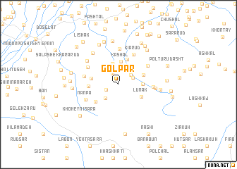
Golpar (Gīlān, Iran)Golpar is a town in the Gīlān region of Iran. An overview map of the region around Golpar is displayed below.
regional and 3d topo map of Golpar, Iran ::
Golpar airports ::
The nearest airport is RAS - Rasht, located 37.4 km north west of Golpar.
Other airports nearby include RZR - Ramsar (75.0 km east), THR - Teheran Mehrabad Intl (200.1 km south east), Nearby towns ::
Şāleḩ Kūh (1.9km north west) //
Zarcheh Sarā (1.7km south west) //
Tūtakī (2.3km north east) //
Angolbar (2.2km north east) //
Āsū (2.1km north east) //
Sīgāsh (2.7km south west) //
Sowt Gavāber (3.3km north) //
Dehgāh (3.4km north) //
Kashal (3.7km north) //
Nīsī (3.1km east) //
Lūnak (3.5km south east) //
Yālkūl (4.2km north) //
Gālesh Zamīn (3.5km north east) //
Malek Rūd-e Bālā (3.6km west) //
Lākārem (4.0km south west) //
Kashūreh (3.8km west) //
Kīārūd (5.1km north) //
Bījār Sarā (4.4km east) //
Līālekal (4.8km north east) //
Sīāh Bījār (4.5km west) //
Kalnādān (5.6km north) //
Malek Rūd-e Pā'īn (4.8km north west) //
Nānpa (4.8km south west) //
Bālā Rūd (4.7km east) //
Malek Rūd (5.5km north west) //
Bozgāh (5.9km north west) //
Lūshā Deh (5.4km east) //
Pashtār Sarā (7.0km north) //
Kāshkī (6.8km north) //
[all distances 'as the bird flies' and approximate]  Places with similar names to Golpar, Iran ::
Disclaimer :: Information on this page comes without warranty of any kind |
||
|
Where is Golpar? Elevation and coordinates ::
Latitude (lat): 37°3'16"N Longitude (lon): 49°51'26"E
Elevation (approx.): 548m (map arrows pan, magnifying glasses zoom) |
||
|
Visiting Golpar? Hotel/Accommodation ::
Book a hotel in Golpar Travel Guide ::
Buy a travel guide for Iran rental cars ::
car rental offers GPS waypoint ::
download a GPX waypoint (PoI) of Golpar for your GPS receiver
|
||