|
search place name
|
||
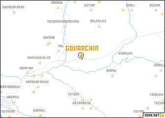
Govarchīn (Kermān, Iran)Govarchīn is a town in the Kermān region of Iran. An overview map of the region around Govarchīn is displayed below.
regional and 3d topo map of Govarchīn, Iran ::
Govarchīn airports ::
The nearest airport is TBZ - Tabriz Intl, located 24.8 km west of Govarchīn.
Nearby towns ::
Sūlūjeh (3.5km north west) //
Sharīfābād (4.7km north west) //
Amand (6.5km south east) //
Qal‘ehlar (8.0km north) //
Marnāb (6.9km north west) //
Tāzeh Kand-e Nahand (8.1km north west) //
Kahlīk Bolāghī (7.1km north west) //
[all distances 'as the bird flies' and approximate] 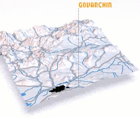 Places with similar names to Govarchīn, Iran ::
// Kovarchino (RU)
// Kafarchīn (IR)
// Khvorshāneh (IR)
// (( Kvarshino )) (RU)
// Kuvarshino (RU)
// Quiévrechain (FR)
Disclaimer :: Information on this page comes without warranty of any kind |
||
|
Where is Govarchīn? Elevation and coordinates ::
Latitude (lat): 38°9'0"N Longitude (lon): 46°31'0"E
Elevation (approx.): 1513m (map arrows pan, magnifying glasses zoom) |
||
|
Visiting Govarchīn? Hotel/Accommodation ::
Book a hotel in Govarchīn Travel Guide ::
Buy a travel guide for Iran rental cars ::
car rental offers GPS waypoint ::
download a GPX waypoint (PoI) of Govarchīn for your GPS receiver
|
||