|
search place name
|
||
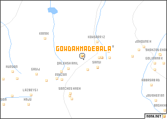
Gowd Aḩmad-e Bālā (Kermān, Iran)Gowd Aḩmad-e Bālā is a town in the Kermān region of Iran. An overview map of the region around Gowd Aḩmad-e Bālā is displayed below.
regional and 3d topo map of Gowd Aḩmad-e Bālā, Iran ::
Gowd Aḩmad-e Bālā airports ::
The nearest airport is KER - Kerman, located 104.0 km east of Gowd Aḩmad-e Bālā.
Other airports nearby include AZD - Yazd Shahid Sadooghi (260.5 km north west), Nearby towns ::
Torsh Āb (2.4km south) //
Zandū'īyeh (3.0km east) //
Sārdī (3.3km south east) //
Lābīd-e Pā'īn (3.3km south east) //
Qal‘eh Shamīl (3.6km south west) //
Roẕū'īyeh (3.6km east) //
Moghū'īyeh (3.6km east) //
Kows̄arrīz (4.8km north east) //
Lāpārīz (5.1km south west) //
Golīlūn (5.1km east) //
Rūdīneh (5.2km east) //
Rāhzan (6.2km south west) //
Parān (6.7km south west) //
Sar Cheshmeh (8.0km south) //
Shūrūʼīyeh (8.7km south) //
Bedū'īyeh (9.2km south) //
Ardīz-e Pā'īn (8.6km south west) //
Kārāk (8.9km north west) //
[all distances 'as the bird flies' and approximate]  Places with similar names to Gowd Aḩmad-e Bālā, Iran :: Disclaimer :: Information on this page comes without warranty of any kind |
||
|
Where is Gowd Aḩmad-e Bālā? Elevation and coordinates ::
Latitude (lat): 30°1'27"N Longitude (lon): 55°54'40"E
Elevation (approx.): 2423m (map arrows pan, magnifying glasses zoom) |
||
|
Visiting Gowd Aḩmad-e Bālā? Hotel/Accommodation ::
Book a hotel in Gowd Aḩmad-e Bālā Travel Guide ::
Buy a travel guide for Iran rental cars ::
car rental offers GPS waypoint ::
download a GPX waypoint (PoI) of Gowd Aḩmad-e Bālā for your GPS receiver
|
||