|
search place name
|
||
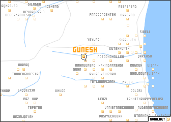
Gūnesh (Gīlān, Iran)Gūnesh is a town in the Gīlān region of Iran. An overview map of the region around Gūnesh is displayed below.
regional and 3d topo map of Gūnesh, Iran ::
Gūnesh airports ::
The nearest airport is RAS - Rasht, located 130.3 km south east of Gūnesh.
Other airports nearby include RZR - Ramsar (228.6 km south east), Nearby towns ::
Ālādīzgeh (0.0km north) //
Maḩmūdābād (1.9km south) //
Bābā ‘Alī (1.9km north) //
Mīeh Kūmeh (1.9km north) //
Shīrī Ḩayāţī (1.5km east) //
Kolambī (2.4km south east) //
Sūhā (3.1km south west) //
Dāshtī (3.4km south east) //
Govāndsar-e Vīznah (4.0km south) //
Yeylāqī (4.0km north) //
Ayūrnī-ye Vīznah (4.7km south east) //
Naz̧ar Maḩalleh (4.4km east) //
Garūf-e Vīznah (5.6km south) //
Meskīn-e Vīznah (5.6km south) //
Ḩakīm Darrehsī (4.7km south east) //
Lūshakī-ye Vīznah (5.7km south) //
Sardāhūnī-ye Vīznah (5.7km south) //
Balājī-ye Vīznah (6.3km south east) //
Yeylāq-e Vīznah (6.3km south east) //
Kerdeh Sarā (6.1km east) //
Kūteh Kūmeh (6.1km east) //
Dīleh (6.9km north east) //
Khvar (8.6km south west) //
[all distances 'as the bird flies' and approximate]  Places with similar names to Gūnesh, Iran ::
Disclaimer :: Information on this page comes without warranty of any kind |
||
|
Where is Gūnesh? Elevation and coordinates ::
Latitude (lat): 38°17'0"N Longitude (lon): 48°45'0"E
Elevation (approx.): 472m (map arrows pan, magnifying glasses zoom) |
||
|
Visiting Gūnesh? Hotel/Accommodation ::
Book a hotel in Gūnesh Travel Guide ::
Buy a travel guide for Iran rental cars ::
car rental offers GPS waypoint ::
download a GPX waypoint (PoI) of Gūnesh for your GPS receiver
|
||