|
search place name
|
||
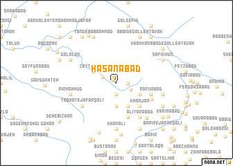
Ḩasanābād (Khūzestān, Iran)Ḩasanābād is a town in the Khūzestān region of Iran. An overview map of the region around Ḩasanābād is displayed below.
regional and 3d topo map of Ḩasanābād, Iran ::
Ḩasanābād airports ::
The nearest airport is QMJ - Masjed Soleiman Shahid Asyaee, located 28.4 km south west of Ḩasanābād.
Other airports nearby include AWZ - Ahwaz (116.3 km south west), MRX - Bandar Mahshahr Mahshahr (187.4 km south), ABD - Abadan (234.7 km south west), BSR - Basrah Intl (249.4 km south west), Nearby towns ::
Ḩoseynābād (0.7km north west) //
Aḩmadābād (1.9km south) //
Gholāmreẕāābād (1.6km east) //
Mandenīābād (1.6km east) //
‘Alī Yār (2.2km north west) //
Boneh-ye Ḩaqqī (2.3km south east) //
Soleymānābād (3.7km south) //
Dehgāh (3.6km south east) //
Mehdīābād (3.6km south east) //
Zeytūnābād (3.6km north west) //
Gāvkhoft (4.0km south east) //
Gholāmābād (4.0km south east) //
Boneh-ye Khvājeh (4.9km south east) //
Boneh-ye Khān Jān (4.9km south east) //
Khānjān (4.9km south east) //
Rafī‘īābād (5.1km east) //
Kandkāh (5.8km south) //
Qal‘eh Khvājeh (5.4km south east) //
Ţāqhā-ye Ja‘far Qolī (6.0km south west) //
‘Alī Yārābād (6.4km south east) //
Garetīn (6.4km south east) //
Shāhū-ye Garatīn (6.4km south east) //
Khān‘alī (7.4km south) //
‘Alī Panāh (7.0km south east) //
Pāy Rāh-e Chāl Balūţak (6.5km west) //
Sharīfābād (6.5km east) //
Pīr Maḩmūd (6.5km west) //
Boneh-ye Bābā Zāhed (8.0km south east) //
Boneh-ye Seyyed (8.0km south east) //
[all distances 'as the bird flies' and approximate] 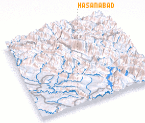 Places with similar names to Ḩasanābād, Iran ::
Disclaimer :: Information on this page comes without warranty of any kind |
||
|
Where is Ḩasanābād? Elevation and coordinates ::
Latitude (lat): 32°14'0"N Longitude (lon): 49°24'0"E
Elevation (approx.): 730m (map arrows pan, magnifying glasses zoom) |
||
|
Visiting Ḩasanābād? Hotel/Accommodation ::
Book a hotel in Ḩasanābād Travel Guide ::
Buy a travel guide for Iran rental cars ::
car rental offers GPS waypoint ::
download a GPX waypoint (PoI) of Ḩasanābād for your GPS receiver
|
||