|
search place name
|
||
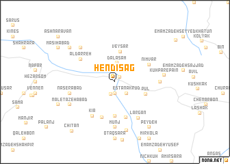
Hendī Sag (Iran)Hendī Sag is a town in Iran. An overview map of the region around Hendī Sag is displayed below.
regional and 3d topo map of Hendī Sag, Iran ::
Hendī Sag airports ::
The nearest airport is THR - Teheran Mehrabad Intl, located 83.1 km south of Hendī Sag.
Other airports nearby include RZR - Ramsar (93.9 km north west), RAS - Rasht (199.3 km north west), Nearby towns ::
Gatehkash (1.0km north east) //
Eslāmābād (1.9km south) //
Kīnj (2.1km south) //
Āstān-e Karūd (2.4km south east) //
Estānak Rūd (2.4km south east) //
Dalasam (3.1km north) //
Veysar (5.0km north) //
Pūl (4.5km south east) //
Emāmzādeh Ebrāhīm (5.6km south) //
Gīl Kolā-ye Zānūs Rostāq-e Kojūr (6.0km south) //
Eslāmābād (6.0km south) //
Nīmvar (5.3km north east) //
Kīā (6.3km south west) //
‘Ālī Darreh (5.8km north west) //
Āl Darreh (5.8km north west) //
Largān (6.6km south east) //
Mūnj (7.4km south) //
Kūh Par-e Bālā (6.0km east) //
Nāşerābād (6.2km west) //
Lash Kenār (7.1km north west) //
Kūh Par-e Pā'īn (6.6km east) //
Khūshal (8.1km south) //
Na‘l-e Tāzehābād (7.0km south west) //
Kondes Kolā (8.2km north west) //
Darvīsh Rostam (8.2km north west) //
Pey Deh (8.7km south east) //
Chītan (9.8km south west) //
[all distances 'as the bird flies' and approximate] 
Disclaimer :: Information on this page comes without warranty of any kind |
||
|
Where is Hendī Sag? Elevation and coordinates ::
Latitude (lat): 36°25'0"N Longitude (lon): 51°32'0"E
Elevation (approx.): 1347m (map arrows pan, magnifying glasses zoom) |
||
|
Visiting Hendī Sag? Hotel/Accommodation ::
Book a hotel in Hendī Sag Travel Guide ::
Buy a travel guide for Iran rental cars ::
car rental offers GPS waypoint ::
download a GPX waypoint (PoI) of Hendī Sag for your GPS receiver
|
||