|
search place name
|
||
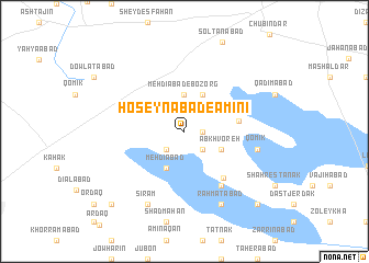
Ḩoseynābād-e Amīnī (Iran)Ḩoseynābād-e Amīnī is a town in Iran. An overview map of the region around Ḩoseynābād-e Amīnī is displayed below.
regional and 3d topo map of Ḩoseynābād-e Amīnī, Iran ::
Ḩoseynābād-e Amīnī airports ::
The nearest airport is RZR - Ramsar, located 111.9 km north east of Ḩoseynābād-e Amīnī.
Other airports nearby include RAS - Rasht (134.6 km north), THR - Teheran Mehrabad Intl (138.2 km east), Nearby towns ::
Ājor Band (1.5km east) //
Morādābād (2.4km south west) //
Ḩakīmābād (2.4km south east) //
Mehdīābād-e Bozorg (3.7km north) //
Mehdīābād (4.0km south) //
Ābkhvoreh (3.5km south east) //
Jannatābād (4.0km north) //
Fārsīān (4.6km east) //
Shāhīn Tappeh (5.7km south east) //
Mavīn (6.3km south east) //
Qomīk (6.3km east) //
Amīnābād (6.3km east) //
Sīram (8.0km south) //
Raḩmatābād (8.0km south) //
Bāqerābād (9.5km south west) //
Mīān Chāl (9.5km south east) //
Kharīvān (9.5km south east) //
Āqā Bābā (9.5km south east) //
[all distances 'as the bird flies' and approximate] 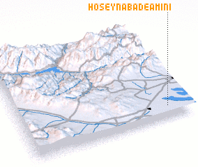 Places with similar names to Ḩoseynābād-e Amīnī, Iran ::
// Ḩasanābād-e Mīān (IR)
// Ḩasanābād-e Mīnū'ī (IR)
Disclaimer :: Information on this page comes without warranty of any kind |
||
|
Where is Ḩoseynābād-e Amīnī? Elevation and coordinates ::
Latitude (lat): 36°8'0"N Longitude (lon): 49°53'0"E
Elevation (approx.): 1231m (map arrows pan, magnifying glasses zoom) |
||
|
Visiting Ḩoseynābād-e Amīnī? Hotel/Accommodation ::
Book a hotel in Ḩoseynābād-e Amīnī Travel Guide ::
Buy a travel guide for Iran rental cars ::
car rental offers GPS waypoint ::
download a GPX waypoint (PoI) of Ḩoseynābād-e Amīnī for your GPS receiver
|
||