|
search place name
|
||
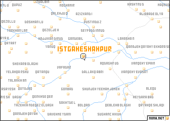
Īstgāh-e Shāhpūr (Ostān-e Āz̄arbāyjān-e Sharqī, Iran)Īstgāh-e Shāhpūr is a town in the Ostān-e Āz̄arbāyjān-e Sharqī region of Iran. An overview map of the region around Īstgāh-e Shāhpūr is displayed below.
regional and 3d topo map of Īstgāh-e Shāhpūr, Iran ::
Īstgāh-e Shāhpūr airports ::
The nearest airport is TBZ - Tabriz Intl, located 106.8 km north west of Īstgāh-e Shāhpūr.
Nearby towns ::
Īstgāh-e Şā‘eb (1.5km east) //
Āghjeh Ūghlān (1.5km east) //
Qīun Qeshlāqī (2.4km north east) //
Qeshlāq (3.7km north) //
Gandebīl (4.0km north) //
Dallāk Qabrī (4.0km south) //
Vafādār (4.4km south west) //
Khvorshīd (4.8km north west) //
Seyf ed Dīn Rūd (5.8km north) //
Āqdāgh Rūd (4.8km south east) //
Gowjeh Qomlāq (5.8km north west) //
Bayāt (6.3km north east) //
Khvājeh Shāhī (5.8km south west) //
Qarah Gol (6.3km south west) //
Pūstīn Dūz (7.6km north) //
Āqdāghrūd (6.2km east) //
Chā'ī Āq Dāgh (6.2km east) //
Yānūq (6.2km west) //
Khvājeh Ghūr (7.0km north east) //
Ḩājjī Kandī Rūd (7.0km north west) //
Shūrjeh-ye Emām Jom‘eh (8.0km south) //
Deh Noqlī (8.0km south) //
Shūrjeh (8.0km south) //
Gonbad (8.0km south) //
Qezeljeh (8.1km north west) //
Qareh Āghāj Kūh (9.5km north west) //
Emām Jom‘eh (9.5km south east) //
Solţānābād (11.0km south east) //
[all distances 'as the bird flies' and approximate] 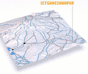 Places with similar names to Īstgāh-e Shāhpūr, Iran :: Disclaimer :: Information on this page comes without warranty of any kind |
||
|
Where is Īstgāh-e Shāhpūr? Elevation and coordinates ::
Latitude (lat): 37°22'0"N Longitude (lon): 46°58'0"E
Elevation (approx.): 1621m (map arrows pan, magnifying glasses zoom) |
||
|
Visiting Īstgāh-e Shāhpūr? Hotel/Accommodation ::
Book a hotel in Īstgāh-e Shāhpūr Travel Guide ::
Buy a travel guide for Iran rental cars ::
car rental offers GPS waypoint ::
download a GPX waypoint (PoI) of Īstgāh-e Shāhpūr for your GPS receiver
|
||