|
search place name
|
||
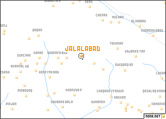
Jalālābād (Lorestān, Iran)Jalālābād is a town in the Lorestān region of Iran. An overview map of the region around Jalālābād is displayed below.
regional and 3d topo map of Jalālābād, Iran ::
Jalālābād airports ::
The nearest airport is QMJ - Masjed Soleiman Shahid Asyaee, located 195.0 km south of Jalālābād.
Other airports nearby include THR - Teheran Mehrabad Intl (268.3 km north east), Nearby towns ::
Rowghanī (1.1km north) //
Darreh Garm (2.3km east) //
Deh-e Aḩmad (3.2km west) //
Zangī Darreh (4.1km west) //
Qareh Malek (4.4km south east) //
Sharafābād (4.7km west) //
Tokhmār (6.9km east) //
Khorūsān (8.2km south) //
Ḩoseynābād (7.4km south west) //
Ḩājjīābād (7.2km west) //
Maḩmūdābād (7.2km west) //
Emāmzādeh Qāsem (9.3km south west) //
Choqā Seyf od Dīn (9.8km south east) //
Āb Bārīk (9.9km north east) //
Karţīlān (10.5km south west) //
Mūchān (10.8km north east) //
[all distances 'as the bird flies' and approximate] 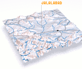 Places with similar names to Jalālābād, Iran ::
Disclaimer :: Information on this page comes without warranty of any kind |
||
|
Where is Jalālābād? Elevation and coordinates ::
Latitude (lat): 33°44'28"N Longitude (lon): 49°34'37"E
Elevation (approx.): 2100m (map arrows pan, magnifying glasses zoom) |
||
|
Visiting Jalālābād? Hotel/Accommodation ::
Book a hotel in Jalālābād Travel Guide ::
Buy a travel guide for Iran rental cars ::
car rental offers GPS waypoint ::
download a GPX waypoint (PoI) of Jalālābād for your GPS receiver
|
||