|
search place name
|
||
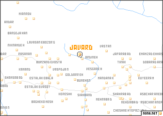
Javard (Tehrān, Iran)Javard is a town in the Tehrān region of Iran. An overview map of the region around Javard is displayed below.
regional and 3d topo map of Javard, Iran ::
Javard airports ::
The nearest airport is THR - Teheran Mehrabad Intl, located 51.5 km west of Javard.
Other airports nearby include RZR - Ramsar (162.6 km north west), Nearby towns ::
Sang Darvāzeh (0.2km south east) //
Jūrd (0.2km south east) //
Ārdīneh (2.2km south east) //
Īrā (2.3km west) //
Vesgāreh (4.4km south east) //
Gol Darreh (5.1km south) //
Būrzand-e ‘Olyā (4.4km west) //
Vāşfejān (5.3km south west) //
Vastān (4.9km east) //
Būm-e Hen (6.4km south) //
Sang Kūh (5.9km south west) //
Lowrān (7.2km south) //
‘Alā'īn (5.9km west) //
Būrzand-e Vosţá (6.2km west) //
Shahrak-e Valī-ye ‘Aşr-e Būm-e Hen (7.6km south) //
Sīārak (7.3km south west) //
Mandānak (7.4km south east) //
Kalān (6.7km west) //
Jowzak (7.1km south west) //
Tajarak-e Bālā (7.3km south east) //
Shahrak-e Felesţīn (8.2km south west) //
Rūdehen (8.2km south east) //
Jājrūd (8.2km south west) //
Ānā (8.4km south east) //
Eşţalak (10.2km south west) //
[all distances 'as the bird flies' and approximate]  Places with similar names to Javard, Iran ::
Disclaimer :: Information on this page comes without warranty of any kind |
||
|
Where is Javard? Elevation and coordinates ::
Latitude (lat): 35°48'7"N Longitude (lon): 51°51'55"E
Elevation (approx.): 2094m (map arrows pan, magnifying glasses zoom) |
||
|
Visiting Javard? Hotel/Accommodation ::
Book a hotel in Javard Travel Guide ::
Buy a travel guide for Iran rental cars ::
car rental offers GPS waypoint ::
download a GPX waypoint (PoI) of Javard for your GPS receiver
|
||