|
search place name
|
||
Kachap Maḩalleh (Iran)Kachap Maḩalleh is a town in Iran. An overview map of the region around Kachap Maḩalleh is displayed below.
regional and 3d topo map of Kachap Maḩalleh, Iran ::

Nearby towns ::
Sefīd Kūh (1.4km south east) //
Rūdbār Maḩalleh (1.7km south west) //
Pā'īn Maḩalleh-ye Keshteleh (1.9km north) //
Esmā‘īl Maḩalleh (2.4km west) //
Eram (3.4km east) //
Ākerd (3.5km north east) //
Valām Deh (5.2km north) //
Nīleh Kūh (5.8km south) //
Kafarāt (4.8km west) //
Chamāz Deh (6.1km north) //
Seyyed Kheyl (5.1km east) //
Deym Dasht (6.3km south east) //
Talam (5.9km west) //
Zāram (6.0km east) //
Sangar (6.2km west) //
Farīmak (7.1km north east) //
Valādīmeh (7.8km north) //
Sūchelmā (6.7km west) //
Valūdī (8.0km north) //
Lā'ī Rūdbār (8.2km north) //
Chenār Bon-e Zārem Rūd (6.8km east) //
Kolā Rūd Bār (8.5km north west) //
Bermā (8.2km north east) //
[all distances 'as the bird flies' and approximate] 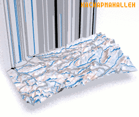 Places with similar names to Kachap Maḩalleh, Iran :: Disclaimer :: Information on this page comes without warranty of any kind |
||
|
Where is Kachap Maḩalleh? Elevation and coordinates ::
Latitude (lat): 36°25'0"N Longitude (lon): 53°40'0"E
Elevation (approx.): 1368m (map arrows pan, magnifying glasses zoom) |
||
|
Visiting Kachap Maḩalleh? Hotel/Accommodation ::
Book a hotel in Kachap Maḩalleh Travel Guide ::
Buy a travel guide for Iran rental cars ::
car rental offers GPS waypoint ::
download a GPX waypoint (PoI) of Kachap Maḩalleh for your GPS receiver
|
||