|
search place name
|
||
Kalgah-e Pahn (Ostān-e Kohgīlūyeh va Būyer Aḩmad, Iran)Kalgah-e Pahn is a town in the Ostān-e Kohgīlūyeh va Būyer Aḩmad region of Iran. An overview map of the region around Kalgah-e Pahn is displayed below.
regional and 3d topo map of Kalgah-e Pahn, Iran ::

Kalgah-e Pahn airports ::
The nearest airport is MRX - Bandar Mahshahr Mahshahr, located 141.0 km west of Kalgah-e Pahn.
Other airports nearby include BUZ - Bushehr (192.0 km south), AWZ - Ahwaz (192.1 km north west), QMJ - Masjed Soleiman Shahid Asyaee (195.8 km north west), SYZ - Shiraz Shahid Dastghaib Intl (227.6 km south east), Nearby towns ::
Deh-e Balūt (5.1km west) //
Ţūf Shīrīn (5.8km north) //
Chīr Bard-e Khāgak (5.5km north east) //
Cheshmeh Neyzeh (6.1km south east) //
Cheshmeh-ye Qāsemī (7.6km north) //
Bīmenjgān (6.9km north west) //
Barm Morghābī (7.3km north east) //
Qal‘eh Dūz (7.0km south east) //
Rashneh Gerd-e ‘Olyā (7.4km south east) //
Borj-e ‘Alī Shīr (8.7km north) //
Emāmzādeh Pīr Pahlavān (8.4km north east) //
[all distances 'as the bird flies' and approximate] 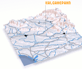 Places with similar names to Kalgah-e Pahn, Iran ::
// Kalgāh-e Pā'īn (IR)
Disclaimer :: Information on this page comes without warranty of any kind |
||
|
Where is Kalgah-e Pahn? Elevation and coordinates ::
Latitude (lat): 30°40'0"N Longitude (lon): 50°37'0"E
Elevation (approx.): 722m (map arrows pan, magnifying glasses zoom) |
||
|
Visiting Kalgah-e Pahn? Hotel/Accommodation ::
Book a hotel in Kalgah-e Pahn Travel Guide ::
Buy a travel guide for Iran rental cars ::
car rental offers GPS waypoint ::
download a GPX waypoint (PoI) of Kalgah-e Pahn for your GPS receiver
|
||