|
search place name
|
||
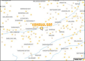
Kamādūl Sar (Gīlān, Iran)Kamādūl Sar is a town in the Gīlān region of Iran. An overview map of the region around Kamādūl Sar is displayed below.
regional and 3d topo map of Kamādūl Sar, Iran ::
Kamādūl Sar airports ::
The nearest airport is RAS - Rasht, located 45.6 km north east of Kamādūl Sar.
Other airports nearby include RZR - Ramsar (140.4 km east), Nearby towns ::
Vezmanā (0.8km north) //
Kūryeh (1.5km north) //
Barakīleh (1.4km north west) //
Raẕī Nesā (2.0km south) //
Khāleşān (2.1km north) //
Lāt (1.8km south east) //
Dorafsheh (2.0km north east) //
Harzel Kūh (2.4km north west) //
Jīrdeh (3.1km north) //
Bāskam Rūbār (3.1km south) //
Zard-e Līcheh (2.9km south west) //
Chopūl (3.0km south east) //
Anjīl-e Boneh (3.2km north west) //
Chopūl Kesh (3.2km west) //
Jamād (3.6km south west) //
Shalāsh Darreh (3.8km north east) //
‘Abbās Kūh (4.2km north) //
Nareh Band (4.3km south) //
Kūreh Kharem (3.6km north west) //
Dahrā (3.8km north west) //
Shārūd (3.6km east) //
Pāpareh (4.7km south) //
Lash (4.0km north west) //
Tūseh Khomār (3.9km west) //
Sīkh Bon (4.4km south west) //
Pā'īzān (4.7km south east) //
Masjed Pīsh (5.2km north east) //
Nemī Hasht (5.1km north west) //
Komādūl (4.8km east) //
[all distances 'as the bird flies' and approximate]  Places with similar names to Kamādūl Sar, Iran :: Disclaimer :: Information on this page comes without warranty of any kind |
||
|
Where is Kamādūl Sar? Elevation and coordinates ::
Latitude (lat): 37°9'53"N Longitude (lon): 49°8'0"E
Elevation (approx.): 622m (map arrows pan, magnifying glasses zoom) |
||
|
Visiting Kamādūl Sar? Hotel/Accommodation ::
Book a hotel in Kamādūl Sar Travel Guide ::
Buy a travel guide for Iran rental cars ::
car rental offers GPS waypoint ::
download a GPX waypoint (PoI) of Kamādūl Sar for your GPS receiver
|
||