|
search place name
|
||
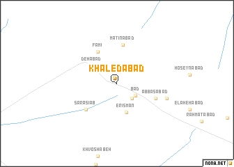
Khāledābād (Eşfahān, Iran)Khāledābād is a town in the Eşfahān region of Iran. An overview map of the region around Khāledābād is displayed below.
regional and 3d topo map of Khāledābād, Iran ::
Khāledābād airports ::
The nearest airport is THR - Teheran Mehrabad Intl, located 228.9 km north of Khāledābād.
Nearby towns ::
Akbarābād (3.1km south east) //
Bād (3.2km south east) //
Dehābād (4.3km north west) //
Erīsmān (4.8km south) //
Famī (5.7km north west) //
Matīnābād (6.2km north) //
Sar Āsīāb (5.9km south west) //
‘Abbāsābād (5.6km south east) //
Mobārakābād (7.1km east) //
[all distances 'as the bird flies' and approximate] 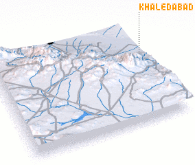 Places with similar names to Khāledābād, Iran ::
// Khuldābād (IN)
// Khāledābād (IR)
// Khāledābād (IR)
// Khāledābād (IR)
// Khalţābād (IR)
// Khaltābād (IR)
// Khal‘atābād (IR)
// Khāledābād (IR)
Disclaimer :: Information on this page comes without warranty of any kind |
||
|
Where is Khāledābād? Elevation and coordinates ::
Latitude (lat): 33°42'16"N Longitude (lon): 51°59'41"E
Elevation (approx.): 989m (map arrows pan, magnifying glasses zoom) |
||
|
Visiting Khāledābād? Hotel/Accommodation ::
Book a hotel in Khāledābād Travel Guide ::
Buy a travel guide for Iran rental cars ::
car rental offers GPS waypoint ::
download a GPX waypoint (PoI) of Khāledābād for your GPS receiver
|
||