|
search place name
|
||
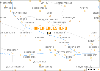
Khalīfeh Qeshlāq (Kordestān, Iran)Khalīfeh Qeshlāq is a town in the Kordestān region of Iran. An overview map of the region around Khalīfeh Qeshlāq is displayed below.
regional and 3d topo map of Khalīfeh Qeshlāq, Iran ::
Khalīfeh Qeshlāq airports ::
The nearest airport is SDG - Sanandaj, located 128.4 km south west of Khalīfeh Qeshlāq.
Other airports nearby include RAS - Rasht (205.2 km north east), KSH - Bakhtaran Shahid Ashrafi Esfahani (216.2 km south), TBZ - Tabriz Intl (250.2 km north west), Nearby towns ::
Gūgtappeh (2.4km south east) //
Ḩājjīābād (3.0km east) //
Alsepehr (3.5km south west) //
Yān Bolāgh (3.5km north east) //
Ḩasanābād-e Yāsūkand (5.0km north) //
Qarāq Tappeh (4.8km north east) //
Sheykh Beshārat (4.8km north west) //
Valī Beyg (5.6km south) //
Yangī Azakh (4.9km east) //
Kharābeh-ye Chehel Arkh (5.8km south) //
Yengī Arkh (5.8km south east) //
Bābā Khān (6.3km south west) //
Gahlī (7.4km north) //
Ḩoseynābād-e Mīrchī (7.6km south) //
Nowshād (7.0km north west) //
Qeychīlū (8.7km south east) //
Seyyed Ḩoseyn (8.7km south east) //
Qomm Ţorqeh (8.2km north east) //
Aḩmadābād (9.5km south west) //
[all distances 'as the bird flies' and approximate] 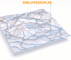 Places with similar names to Khalīfeh Qeshlāq, Iran ::
// Khalīfeh Qeshlāq (IR)
// Khalīfeh Qeshlāqī (IR)
Disclaimer :: Information on this page comes without warranty of any kind |
||
|
Where is Khalīfeh Qeshlāq? Elevation and coordinates ::
Latitude (lat): 36°14'0"N Longitude (lon): 47°45'0"E
Elevation (approx.): 1544m (map arrows pan, magnifying glasses zoom) |
||
|
Visiting Khalīfeh Qeshlāq? Hotel/Accommodation ::
Book a hotel in Khalīfeh Qeshlāq Travel Guide ::
Buy a travel guide for Iran rental cars ::
car rental offers GPS waypoint ::
download a GPX waypoint (PoI) of Khalīfeh Qeshlāq for your GPS receiver
|
||