|
search place name
|
||
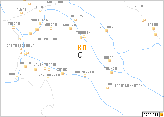
Kīn (Lorestān, Iran)Kīn is a town in the Lorestān region of Iran. An overview map of the region around Kīn is displayed below.
regional and 3d topo map of Kīn, Iran ::
Kīn airports ::
The nearest airport is QMJ - Masjed Soleiman Shahid Asyaee, located 96.1 km south west of Kīn.
Other airports nearby include AWZ - Ahwaz (183.8 km south west), Nearby towns ::
Pol Z̄arreh (3.9km south) //
Tūreh (4.6km north) //
Dīzābād (4.8km north) //
Tabareh (5.2km north) //
Rīsvāsehgūn (4.5km west) //
Zarak (5.0km south west) //
Hīrān (5.2km east) //
Gandāb (7.2km north) //
Telkow (6.4km south east) //
Lāveh-ye Bālā (6.8km west) //
Tīt Mollā (6.8km west) //
Halīkābād (7.9km north east) //
Galeh Khūn (7.4km north west) //
Lāveh-ye Pā'īn (7.3km west) //
Sevah (8.3km south east) //
Darreh Pareh (7.9km south west) //
Kīsh-e ‘Olyā (9.0km north) //
Jīrgāh (9.0km north west) //
[all distances 'as the bird flies' and approximate] 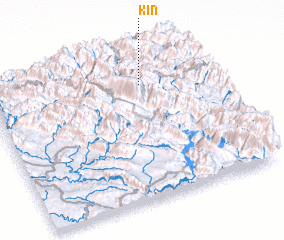 Places with similar names to Kīn, Iran ::
Disclaimer :: Information on this page comes without warranty of any kind |
||
|
Where is Kīn? Elevation and coordinates ::
Latitude (lat): 32°47'5"N Longitude (lon): 49°42'38"E
Elevation (approx.): 2129m (map arrows pan, magnifying glasses zoom) |
||
|
Visiting Kīn? Hotel/Accommodation ::
Book a hotel in Kīn Travel Guide ::
Buy a travel guide for Iran rental cars ::
car rental offers GPS waypoint ::
download a GPX waypoint (PoI) of Kīn for your GPS receiver
|
||