|
search place name
|
||
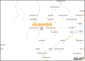
Kolbeh Sard (Iran)Kolbeh Sard is a town in Iran. An overview map of the region around Kolbeh Sard is displayed below.
regional and 3d topo map of Kolbeh Sard, Iran ::
Kolbeh Sard airports ::
The nearest airport is RZR - Ramsar, located 53.9 km north west of Kolbeh Sard.
Other airports nearby include THR - Teheran Mehrabad Intl (95.2 km south), RAS - Rasht (155.7 km north west), Nearby towns ::
Shūr Zamīn (1.9km north) //
Māzū Chāl (2.4km north east) //
Bāb Rūdbār (2.4km south west) //
Sefīdkhānī (3.0km west) //
Shalamjer (3.0km east) //
Kak Neshīn (4.0km north) //
Polī Darreh (4.0km north) //
Shīrvār (4.8km north west) //
Gonār (4.8km north west) //
Şāfkhūnī (4.8km north east) //
Sard Āb (4.8km north east) //
Āneh Sarā (4.5km east) //
Sāyadīm (5.6km south) //
Tazār (5.8km north) //
Sardān (4.8km south east) //
Halūdārān (5.8km north east) //
Lahsā Kūtī (6.3km north west) //
Zīrgāv (6.3km north east) //
[all distances 'as the bird flies' and approximate] 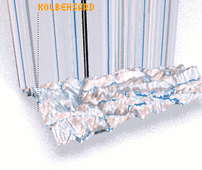 Places with similar names to Kolbeh Sard, Iran ::
// Qal‘eh Bezarūd (IR)
Disclaimer :: Information on this page comes without warranty of any kind |
||
|
Where is Kolbeh Sard? Elevation and coordinates ::
Latitude (lat): 36°31'0"N Longitude (lon): 51°2'0"E
Elevation (approx.): 1859m (map arrows pan, magnifying glasses zoom) |
||
|
Visiting Kolbeh Sard? Hotel/Accommodation ::
Book a hotel in Kolbeh Sard Travel Guide ::
Buy a travel guide for Iran rental cars ::
car rental offers GPS waypoint ::
download a GPX waypoint (PoI) of Kolbeh Sard for your GPS receiver
|
||