|
search place name
|
||
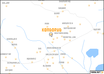
Kondo Rūd (Ostān-e Āz̄arbāyjān-e Sharqī, Iran)Kondo Rūd is a town in the Ostān-e Āz̄arbāyjān-e Sharqī region of Iran. An overview map of the region around Kondo Rūd is displayed below.
regional and 3d topo map of Kondo Rūd, Iran ::
Kondo Rūd airports ::
The nearest airport is TBZ - Tabriz Intl, located 36.2 km east of Kondo Rūd.
Nearby towns ::
Golābād (0.8km south east) //
Bas Kandīzaj (1.8km south) //
Sarkand-e Dīzaj (1.4km east) //
Mehtar Aḩmad (2.8km east) //
Pīām (4.0km north) //
‘Alī Akbarlū (3.6km east) //
Amīr Zakarīyā (5.1km south) //
Ne‘matollāh (5.2km east) //
Sīs (6.3km south west) //
Sefīd Kamar (5.5km east) //
Hārūnīyeh (6.0km north east) //
Malekzādeh (7.4km south) //
Sīkī (6.9km south west) //
Sīvān (7.6km north) //
Gholāmlū (8.2km south) //
Zangī (8.0km south east) //
Naz̧arlū (9.5km south east) //
[all distances 'as the bird flies' and approximate] 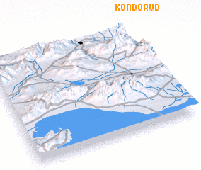 Places with similar names to Kondo Rūd, Iran ::
Disclaimer :: Information on this page comes without warranty of any kind |
||
|
Where is Kondo Rūd? Elevation and coordinates ::
Latitude (lat): 38°14'58"N Longitude (lon): 45°50'55"E
Elevation (approx.): 1491m (map arrows pan, magnifying glasses zoom) |
||
|
Visiting Kondo Rūd? Hotel/Accommodation ::
Book a hotel in Kondo Rūd Travel Guide ::
Buy a travel guide for Iran rental cars ::
car rental offers GPS waypoint ::
download a GPX waypoint (PoI) of Kondo Rūd for your GPS receiver
|
||