|
search place name
|
||
Kūchek Dīgī Seyyed (Golestān, Iran)Kūchek Dīgī Seyyed is a town in the Golestān region of Iran. An overview map of the region around Kūchek Dīgī Seyyed is displayed below.
regional and 3d topo map of Kūchek Dīgī Seyyed, Iran ::
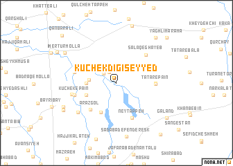
Nearby towns ::
Kanīzak (2.0km north west) //
Kūchek Khorţūm (2.2km north west) //
Oveh Palang (3.6km west) //
Sāzemān-e Goldasht (3.9km west) //
Sāzemān-e Balūchābād (4.3km south west) //
Lāleh Bāgh (5.2km south west) //
Arāz Gol (5.5km south west) //
Ney Tappeh (6.0km south) //
Lāleh Bāgh (6.0km south) //
Khvājeh Mardī Khān (5.0km east) //
Tātār-e Pā'īn (5.1km east) //
Salāq-e Ghāyeb (5.9km north east) //
Ābeh Qīlīj (5.6km west) //
Kūchek-e Pā'īn (5.7km west) //
Kūchek Astājīq (6.0km west) //
Moḩammad Javāl (6.8km south west) //
Sa‘dābād-e Fenderesk (8.8km south) //
Badrāq-e Ānāgaldī (7.8km south west) //
Īmer Tūr Mollā (8.2km north west) //
Rūsh (8.9km north east) //
Kūchek-e Bālā (8.2km south west) //
Galand (8.6km south east) //
Kalūkan (10.0km south east) //
Yāghlī Mārāmā (9.8km north east) //
Bāghlī Mārāmā (9.8km north east) //
Qanbar ‘Alī (10.4km north west) //
[all distances 'as the bird flies' and approximate]  Places with similar names to Kūchek Dīgī Seyyed, Iran :: Disclaimer :: Information on this page comes without warranty of any kind |
||
|
Where is Kūchek Dīgī Seyyed? Elevation and coordinates ::
Latitude (lat): 37°5'3"N Longitude (lon): 54°56'37"E
Elevation (approx.): 24m (map arrows pan, magnifying glasses zoom) |
||
|
Visiting Kūchek Dīgī Seyyed? Hotel/Accommodation ::
Book a hotel in Kūchek Dīgī Seyyed Travel Guide ::
Buy a travel guide for Iran rental cars ::
car rental offers GPS waypoint ::
download a GPX waypoint (PoI) of Kūchek Dīgī Seyyed for your GPS receiver
|
||