|
search place name
|
||
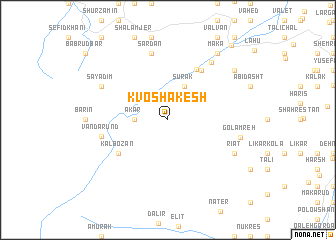
Kvoshākesh (Iran)Kvoshākesh is a town in Iran. An overview map of the region around Kvoshākesh is displayed below.
regional and 3d topo map of Kvoshākesh, Iran ::
Kvoshākesh airports ::
The nearest airport is RZR - Ramsar, located 64.9 km north west of Kvoshākesh.
Other airports nearby include THR - Teheran Mehrabad Intl (84.8 km south), RAS - Rasht (166.0 km north west), Nearby towns ::
Ākar (3.0km west) //
Sūrak (4.0km north) //
Rūdbārak (6.2km north east) //
Mejel (6.3km north east) //
Kal Bozān (5.8km south west) //
Vandārūnd (6.2km west) //
Sardān (7.6km north) //
Ajābīt (7.5km north east) //
Rīāt (7.0km south east) //
Sāyadīm (7.0km north west) //
Golāmreh (6.8km east) //
Makā' (8.7km north east) //
Qaşr-e Salţanatī (8.2km north east) //
Ḩasan Kīf (10.1km north east) //
[all distances 'as the bird flies' and approximate]  Places with similar names to Kvoshākesh, Iran :: Disclaimer :: Information on this page comes without warranty of any kind |
||
|
Where is Kvoshākesh? Elevation and coordinates ::
Latitude (lat): 36°26'0"N Longitude (lon): 51°6'0"E
Elevation (approx.): 2968m (map arrows pan, magnifying glasses zoom) |
||
|
Visiting Kvoshākesh? Hotel/Accommodation ::
Book a hotel in Kvoshākesh Travel Guide ::
Buy a travel guide for Iran rental cars ::
car rental offers GPS waypoint ::
download a GPX waypoint (PoI) of Kvoshākesh for your GPS receiver
|
||