|
search place name
|
||
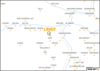
Laher (Iran)Laher is a town in Iran. An overview map of the region around Laher is displayed below.
regional and 3d topo map of Laher, Iran ::
Laher airports ::
The nearest airport is THR - Teheran Mehrabad Intl, located 91.7 km south west of Laher.
Other airports nearby include RZR - Ramsar (166.5 km north west), Nearby towns ::
Dastrān (0.0km north) //
Kīān (1.9km south) //
Sovā (1.9km north) //
Amreh (3.5km north west) //
Emāmzādeh Kheyr (3.5km south east) //
Razān (4.0km south) //
Kahrūd-e Bālā (4.1km east) //
Panjāb (4.8km north east) //
Mīān Deh (4.8km south west) //
Nāndal (4.8km south west) //
Kahrūd-e Pā'īn (4.5km east) //
Fīs (4.9km west) //
Darreh Kenār (4.9km west) //
Ḩājjī Delā (5.8km south) //
Nal (7.3km south) //
‘Abd ol Manāf (6.3km west) //
‘Alīābād (7.0km north east) //
Oţāq Sarā (7.0km north west) //
Nesel (7.0km north west) //
Hardo Rūd (9.5km north east) //
Moḩammadābād (9.5km south east) //
[all distances 'as the bird flies' and approximate]  Places with similar names to Laher, Iran ::
Disclaimer :: Information on this page comes without warranty of any kind |
||
|
Where is Laher? Elevation and coordinates ::
Latitude (lat): 36°4'0"N Longitude (lon): 52°13'0"E
Elevation (approx.): 1791m (map arrows pan, magnifying glasses zoom) |
||
|
Visiting Laher? Hotel/Accommodation ::
Book a hotel in Laher Travel Guide ::
Buy a travel guide for Iran rental cars ::
car rental offers GPS waypoint ::
download a GPX waypoint (PoI) of Laher for your GPS receiver
|
||