|
search place name
|
||
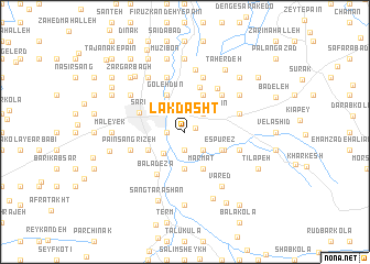
Lāk Dasht (Iran)Lāk Dasht is a town in Iran. An overview map of the region around Lāk Dasht is displayed below.
regional and 3d topo map of Lāk Dasht, Iran ::
Lāk Dasht airports ::
The nearest airport is THR - Teheran Mehrabad Intl, located 187.1 km south west of Lāk Dasht.
Nearby towns ::
Āb Bandān Sar (0.9km north east) //
Āsīāb Sar (1.9km south) //
Now Deh (1.9km south) //
Pol Gardan (1.5km west) //
Āzād Goleh (2.2km north) //
Āb Bandān Kash (2.4km south east) //
Hevelā-ye Bālā (2.4km north east) //
Hevelā-ye Pā'īn (2.4km north east) //
Z̄oghāl Chāl (2.4km north east) //
Pā'īn Dezā (2.8km south west) //
Khān ‘Abbāsī (3.7km south) //
Espūrez (3.5km south east) //
Marmat (4.0km south) //
Kūh Dasht (3.5km south west) //
Āhū Dasht (3.5km south west) //
Gol Chīnī (3.5km south west) //
Bālā Ābdāng (4.0km north) //
Goleh Dūn (4.0km north) //
Gallehdūn (4.0km north) //
Gūg Bāgh (4.0km north) //
Esbūrez (3.7km south east) //
Ḩoseynābād (4.7km north) //
Sārī (4.2km north west) //
Bālā Dezā (4.9km south west) //
Semes Kandeh-ye Bālā (4.8km north east) //
Mīān Kūcheh (4.8km north east) //
Hemmatābād (5.2km north east) //
Bandafrūz (4.8km south east) //
Shas Kandeh (4.8km north east) //
[all distances 'as the bird flies' and approximate] 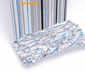 Places with similar names to Lāk Dasht, Iran ::
// Lāk Dasht (IR)
Disclaimer :: Information on this page comes without warranty of any kind |
||
|
Where is Lāk Dasht? Elevation and coordinates ::
Latitude (lat): 36°33'0"N Longitude (lon): 53°6'0"E
Elevation (approx.): 51m (map arrows pan, magnifying glasses zoom) |
||
|
Visiting Lāk Dasht? Hotel/Accommodation ::
Book a hotel in Lāk Dasht Travel Guide ::
Buy a travel guide for Iran rental cars ::
car rental offers GPS waypoint ::
download a GPX waypoint (PoI) of Lāk Dasht for your GPS receiver
|
||