|
search place name
|
||
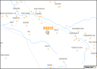
Mārīn (Ostān-e Kohgīlūyeh va Būyer Aḩmad, Iran)Mārīn is a town in the Ostān-e Kohgīlūyeh va Būyer Aḩmad region of Iran. An overview map of the region around Mārīn is displayed below.
regional and 3d topo map of Mārīn, Iran ::
Mārīn airports ::
The nearest airport is MRX - Bandar Mahshahr Mahshahr, located 160.8 km west of Mārīn.
Other airports nearby include BUZ - Bushehr (180.1 km south), SYZ - Shiraz Shahid Dastghaib Intl (204.7 km south east), QMJ - Masjed Soleiman Shahid Asyaee (217.3 km north west), Nearby towns ::
Fatḩ (2.8km east) //
Nīm Dowr (5.1km north west) //
Mazīz (5.7km south) //
Mūger (6.7km north west) //
Dīl (6.4km west) //
Pā Gach (7.6km north) //
Rūdbāl (7.7km north west) //
Aspar (8.2km north west) //
Kheyrmand (9.4km north) //
Seyyed Jamāl od Dīn (9.9km north west) //
Sar Tīrah (10.3km north west) //
Nāzmakān-e Pā'īn (10.3km north west) //
Hejrat (10.3km north west) //
[all distances 'as the bird flies' and approximate] 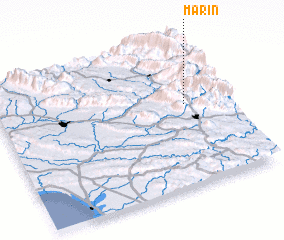 Places with similar names to Mārīn, Iran ::
Disclaimer :: Information on this page comes without warranty of any kind |
||
|
Where is Mārīn? Elevation and coordinates ::
Latitude (lat): 30°34'9"N Longitude (lon): 50°49'39"E
Elevation (approx.): 2082m (map arrows pan, magnifying glasses zoom) |
||
|
Visiting Mārīn? Hotel/Accommodation ::
Book a hotel in Mārīn Travel Guide ::
Buy a travel guide for Iran rental cars ::
car rental offers GPS waypoint ::
download a GPX waypoint (PoI) of Mārīn for your GPS receiver
|
||