|
search place name
|
||
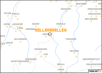
Mollā Maḩalleh (Iran)Mollā Maḩalleh is a town in Iran. An overview map of the region around Mollā Maḩalleh is displayed below.
regional and 3d topo map of Mollā Maḩalleh, Iran ::
Mollā Maḩalleh airports ::
The nearest airport is THR - Teheran Mehrabad Intl, located 100.7 km south west of Mollā Maḩalleh.
Other airports nearby include RZR - Ramsar (134.4 km north west), Nearby towns ::
Sādāt Maḩalleh (0.0km north) //
Khaţīb Kolā (0.0km north) //
Mollā Kolā (0.0km north) //
Korchī (1.5km west) //
Behbanak (1.5km west) //
Dīzīn Kolā (2.4km north east) //
Tangeh-ye Lāvīj (4.8km north east) //
Ra'īs Kolā (4.8km north east) //
Āqā Seyyed Ḩoseyn (4.8km north east) //
Shahrdār Maḩalleh (4.8km north west) //
Moshkā Khānī (6.3km south west) //
Sūrdār (5.8km north west) //
Īzvā (7.6km south) //
Tangeh Sar (6.2km east) //
Chāl Sarā (8.0km south) //
Vāz-e Pā'īn (9.3km south east) //
[all distances 'as the bird flies' and approximate]  Places with similar names to Mollā Maḩalleh, Iran ::
// Malomhely (HU)
// Mollā Maḩalleh (IR)
// Mollā Maḩalleh (IR)
// Mollā Maḩalleh (IR)
// Mollā Maḩalleh (IR)
Disclaimer :: Information on this page comes without warranty of any kind |
||
|
Where is Mollā Maḩalleh? Elevation and coordinates ::
Latitude (lat): 36°23'0"N Longitude (lon): 52°2'0"E
Elevation (approx.): 606m (map arrows pan, magnifying glasses zoom) |
||
|
Visiting Mollā Maḩalleh? Hotel/Accommodation ::
Book a hotel in Mollā Maḩalleh Travel Guide ::
Buy a travel guide for Iran rental cars ::
car rental offers GPS waypoint ::
download a GPX waypoint (PoI) of Mollā Maḩalleh for your GPS receiver
|
||