|
search place name
|
||
Namak Nār (Iran)Namak Nār is a town in Iran. An overview map of the region around Namak Nār is displayed below.
regional and 3d topo map of Namak Nār, Iran ::

Namak Nār airports ::
The nearest airport is MRX - Bandar Mahshahr Mahshahr, located 122.1 km west of Namak Nār.
Other airports nearby include QMJ - Masjed Soleiman Shahid Asyaee (156.8 km north west), AWZ - Ahwaz (157.9 km west), BUZ - Bushehr (225.3 km south), Nearby towns ::
Kal Sūr (0.0km north) //
Mīr Ḩeydar (1.1km north east) //
Ābmū ‘Olyā (1.6km south) //
Ţūf Kheymeh (1.9km south) //
Sarţūf (1.9km south) //
Zoj-e Soflá (1.6km west) //
Zīrpar (1.6km east) //
Zīr Zeydān (2.4km south west) //
Barkashkī-ye Pā'īn (2.4km south east) //
Barkashkī-ye Bālā (2.4km south east) //
Dūk (2.4km north west) //
Sīm Kūtāh (2.4km north west) //
Mīrzā Khūnī (3.2km south west) //
Chendār-e Qavī (3.7km north) //
Āb Bīd (3.7km south) //
Gūrābād (3.2km west) //
Cheshmeh Bāgh (3.2km west) //
Cheshmeh Shīrīnow (4.0km south) //
Zoj-e ‘Olyā (3.5km west) //
Chahār Jūdūn (3.7km north east) //
Gerd Bīsheh (3.7km north west) //
Dūl Ābzā (4.0km south west) //
Ātashgāh-e Pā'īn (4.0km north east) //
Darreh Zang (4.0km north east) //
Bādāmestān-e Pā'īn (4.0km north west) //
Damleh (4.5km north east) //
Bībī Zoleykhā'ī (4.5km east) //
Bādāmestān-e Bālā (5.6km north) //
Kalgeh Zarī (5.6km south) //
[all distances 'as the bird flies' and approximate] 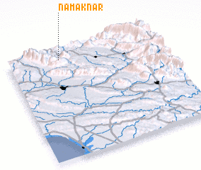 Places with similar names to Namak Nār, Iran :: Disclaimer :: Information on this page comes without warranty of any kind |
||
|
Where is Namak Nār? Elevation and coordinates ::
Latitude (lat): 30°56'0"N Longitude (lon): 50°21'0"E
Elevation (approx.): 581m (map arrows pan, magnifying glasses zoom) |
||
|
Visiting Namak Nār? Hotel/Accommodation ::
Book a hotel in Namak Nār Travel Guide ::
Buy a travel guide for Iran rental cars ::
car rental offers GPS waypoint ::
download a GPX waypoint (PoI) of Namak Nār for your GPS receiver
|
||