|
search place name
|
||
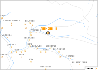
Nāmānlū (Khorāsān, Iran)Nāmānlū is a town in the Khorāsān region of Iran. An overview map of the region around Nāmānlū is displayed below.
regional and 3d topo map of Nāmānlū, Iran ::
Nāmānlū airports ::
The nearest airport is ASB - Ashkhabad Ashgabat, located 41.8 km north east of Nāmānlū.
Nearby towns ::
Zenīdānlū (4.1km west) //
Qāltamānlū (4.1km west) //
Sherkānlū (5.2km south) //
Dūlū (6.6km south) //
Qal‘eh Valī (6.6km south) //
Naqdū (6.6km south) //
Mīlānlū-ye Pāʼīn (5.4km west) //
Khalājlū (6.2km south west) //
Charmeh (5.5km west) //
Moḩammad Dūlū (7.0km south) //
Mīlānlū-ye Bālā (6.3km north west) //
Takht (6.0km west) //
Qal‘eh Ḩasan (7.1km south east) //
Rashvānlū (6.2km west) //
Do Āb (7.2km south west) //
Malvānlū (7.4km north west) //
Qal‘eh Bīg (8.6km south east) //
Sīsparānlū-ye Bālā (7.6km west) //
Pīrūdānlū (9.0km south) //
[all distances 'as the bird flies' and approximate] 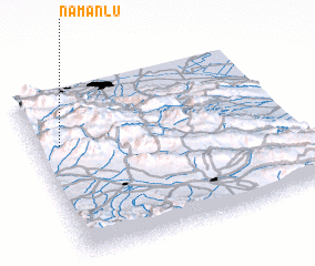 Places with similar names to Nāmānlū, Iran ::
// Naimnule (ID)
// New Manila (PH)
Disclaimer :: Information on this page comes without warranty of any kind |
||
|
Where is Nāmānlū? Elevation and coordinates ::
Latitude (lat): 37°40'30"N Longitude (lon): 58°5'43"E
Elevation (approx.): 1798m (map arrows pan, magnifying glasses zoom) |
||
|
Visiting Nāmānlū? Hotel/Accommodation ::
Book a hotel in Nāmānlū Travel Guide ::
Buy a travel guide for Iran rental cars ::
car rental offers GPS waypoint ::
download a GPX waypoint (PoI) of Nāmānlū for your GPS receiver
|
||