|
search place name
|
||
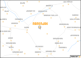
Nārenjak (Kordestān, Iran)Nārenjak is a town in the Kordestān region of Iran. An overview map of the region around Nārenjak is displayed below.
regional and 3d topo map of Nārenjak, Iran ::
Nārenjak airports ::
The nearest airport is SDG - Sanandaj, located 99.6 km west of Nārenjak.
Other airports nearby include KSH - Bakhtaran Shahid Ashrafi Esfahani (119.7 km south west), Nearby towns ::
Gandāb-e Pāʼīn (3.3km south east) //
Dūsar (5.1km west) //
Gandāb-e ‘Olyā (5.4km west) //
Bābā Sheydollāh (6.6km north east) //
Dāsh Kasan (7.1km north) //
Jodā Qāyeh (7.9km north west) //
Şandūqābād (8.7km south east) //
Āq Bolāgh (10.5km south east) //
[all distances 'as the bird flies' and approximate]  Places with similar names to Nārenjak, Iran ::
// Nārinjūk (IQ)
Disclaimer :: Information on this page comes without warranty of any kind |
||
|
Where is Nārenjak? Elevation and coordinates ::
Latitude (lat): 35°6'11"N Longitude (lon): 48°5'21"E
Elevation (approx.): 1881m (map arrows pan, magnifying glasses zoom) |
||
|
Visiting Nārenjak? Hotel/Accommodation ::
Book a hotel in Nārenjak Travel Guide ::
Buy a travel guide for Iran rental cars ::
car rental offers GPS waypoint ::
download a GPX waypoint (PoI) of Nārenjak for your GPS receiver
|
||