|
search place name
|
||
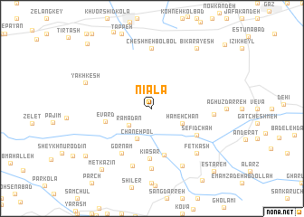
Nīālā (Iran)Nīālā is a town in Iran. An overview map of the region around Nīālā is displayed below.
regional and 3d topo map of Nīālā, Iran ::
Nearby towns ::
Ramadān (3.1km south west) //
Chāneh Pol (4.0km south) //
Hameh Chān (3.5km south east) //
Moşayyeb Maḩalleh (3.5km south east) //
Band-e Sar (5.9km south) //
Evārd (4.9km west) //
Kīā Sar (6.2km south) //
Sefīd Chāh (5.5km south east) //
Gornām (6.3km south west) //
Kīāsar-e Pā'īn (7.4km south) //
Cheshmeh Bolbol (7.4km north) //
Bīsheh Boneh (7.4km south) //
Vezvār (6.2km east) //
Fetkash (7.1km south east) //
Kaftar Gār (7.8km south east) //
Yakh Kesh (7.3km north west) //
Bīkārāyesh (8.7km north east) //
Metkāzīn (9.0km south west) //
Pārem (8.8km south west) //
Vaneshīd (10.1km south east) //
Estārem (9.9km south east) //
Noşratābād (10.3km north west) //
[all distances 'as the bird flies' and approximate]  Places with similar names to Nīālā, Iran ::
Disclaimer :: Information on this page comes without warranty of any kind |
||
|
Where is Nīālā? Elevation and coordinates ::
Latitude (lat): 36°38'0"N Longitude (lon): 53°50'0"E
Elevation (approx.): 1462m (map arrows pan, magnifying glasses zoom) |
||
|
Visiting Nīālā? Hotel/Accommodation ::
Book a hotel in Nīālā Travel Guide ::
Buy a travel guide for Iran rental cars ::
car rental offers GPS waypoint ::
download a GPX waypoint (PoI) of Nīālā for your GPS receiver
|
||