|
search place name
|
||
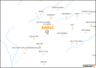
Nīmrūz (Khorāsān, Iran)Nīmrūz is a town in the Khorāsān region of Iran. An overview map of the region around Nīmrūz is displayed below.
regional and 3d topo map of Nīmrūz, Iran ::
Nīmrūz airports ::
The nearest airport is XBJ - Birjand, located 116.7 km south of Nīmrūz.
Nearby towns ::
Ḩaẕratī (0.0km north) //
Taj rūd (2.9km north) //
Āchānī (3.1km north east) //
Ḩoseynābād (4.0km north east) //
Kalāteh-ye Now (4.0km north west) //
Ḩātamābād (4.6km east) //
Mahyār (5.5km south west) //
Senjetak (5.0km west) //
Deh Mīr (6.5km north) //
Makārom (6.7km north) //
Kūh Balgī (7.9km south) //
Sūr (7.8km north west) //
Moqrī (8.2km north) //
Jowz Andar (8.2km north) //
Dar Sefīd (8.9km north west) //
Jabbār (8.6km north east) //
Mādar Qolī (9.2km north east) //
Kalāteh-ye Ḩājjī Moḩammd-e‘ Alam (9.5km south west) //
[all distances 'as the bird flies' and approximate] 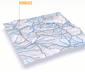 Places with similar names to Nīmrūz, Iran ::
Disclaimer :: Information on this page comes without warranty of any kind |
||
|
Where is Nīmrūz? Elevation and coordinates ::
Latitude (lat): 33°57'0"N Longitude (lon): 59°16'0"E
Elevation (approx.): 1618m (map arrows pan, magnifying glasses zoom) |
||
|
Visiting Nīmrūz? Hotel/Accommodation ::
Book a hotel in Nīmrūz Travel Guide ::
Buy a travel guide for Iran rental cars ::
car rental offers GPS waypoint ::
download a GPX waypoint (PoI) of Nīmrūz for your GPS receiver
|
||