|
search place name
|
||
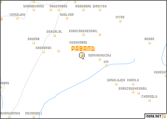
Pāband (Iran)Pāband is a town in Iran. An overview map of the region around Pāband is displayed below.
regional and 3d topo map of Pāband, Iran ::
Pāband airports ::
The nearest airport is RAS - Rasht, located 139.3 km north east of Pāband.
Other airports nearby include RZR - Ramsar (185.5 km north east), SDG - Sanandaj (195.2 km south west), KSH - Bakhtaran Shahid Ashrafi Esfahani (258.5 km south west), Nearby towns ::
Kūshkābād (3.1km north) //
Sorkheh Dīzaj (3.0km east) //
Vīk (4.4km east) //
Emāmzādeh Esmā‘īl (5.6km north) //
Kabūtarak (4.9km west) //
Torkān Deh (6.3km north east) //
Deh Jalāl (7.5km north west) //
Khomārak (7.4km west) //
Dāshlūjeh (8.2km south east) //
Vīyar (10.9km north east) //
[all distances 'as the bird flies' and approximate]  Places with similar names to Pāband, Iran ::
// Poubouandi (BF)
// Poubaindi I (CF)
// Pebondo (ID)
// Pā Band (IR)
// Pāband (IR)
// Pai Bento (BR)
Disclaimer :: Information on this page comes without warranty of any kind |
||
|
Where is Pāband? Elevation and coordinates ::
Latitude (lat): 36°16'0"N Longitude (lon): 48°46'0"E
Elevation (approx.): 1979m (map arrows pan, magnifying glasses zoom) |
||
|
Visiting Pāband? Hotel/Accommodation ::
Book a hotel in Pāband Travel Guide ::
Buy a travel guide for Iran rental cars ::
car rental offers GPS waypoint ::
download a GPX waypoint (PoI) of Pāband for your GPS receiver
|
||