|
search place name
|
||
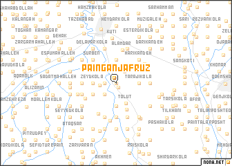
Pā'īn Ganj Afrūz (Iran)Pā'īn Ganj Afrūz is a town in Iran. An overview map of the region around Pā'īn Ganj Afrūz is displayed below.
regional and 3d topo map of Pā'īn Ganj Afrūz, Iran ::
Pā'īn Ganj Afrūz airports ::
The nearest airport is THR - Teheran Mehrabad Intl, located 151.8 km south west of Pā'īn Ganj Afrūz.
Nearby towns ::
Deh Mīān (0.0km north) //
Rowshanābād (0.8km south east) //
Mo‘allem Kolā (1.5km west) //
Mīrūd Posht (2.2km north east) //
Now Shīrvān Kolā (2.1km west) //
Seyyed Kolā (2.4km south west) //
Sādāt Maḩalleh (2.4km south west) //
Armak (3.0km north west) //
Tarājī Kolā (3.0km east) //
Kelāgar Maḩalleh (3.0km west) //
Zeyd Kolā (3.0km west) //
Tork Maḩalleh (3.7km north) //
Gāvzan Kolā-ye Shāh Reẕā (3.7km south) //
Showb Maḩalleh (3.7km south) //
Gāvzan Maḩalleh (3.7km south) //
Ţalvat (3.7km south) //
Tolūt (3.6km south) //
Pā'īn Serest (3.5km south west) //
Chārī (4.5km south) //
Harī Kandeh (4.8km north east) //
Yūrsīāh-e Kolā Maḩalleh (4.8km north west) //
Ḩājjī Kolā (4.8km north west) //
Sūrben (4.8km north west) //
Ḩājjī Kolā Pā'īn (4.8km north west) //
‘Alamdār (5.3km north) //
Hatkeh Posht (4.8km north east) //
Dīv Dasht (4.5km east) //
Rūd Bār Maḩalleh (5.6km south) //
Sarūn Kheyr (4.5km west) //
[all distances 'as the bird flies' and approximate]  Places with similar names to Pā'īn Ganj Afrūz, Iran :: Disclaimer :: Information on this page comes without warranty of any kind |
||
|
Where is Pā'īn Ganj Afrūz? Elevation and coordinates ::
Latitude (lat): 36°28'0"N Longitude (lon): 52°42'0"E
Elevation (approx.): 17m (map arrows pan, magnifying glasses zoom) |
||
|
Visiting Pā'īn Ganj Afrūz? Hotel/Accommodation ::
Book a hotel in Pā'īn Ganj Afrūz Travel Guide ::
Buy a travel guide for Iran rental cars ::
car rental offers GPS waypoint ::
download a GPX waypoint (PoI) of Pā'īn Ganj Afrūz for your GPS receiver
|
||