|
search place name
|
||
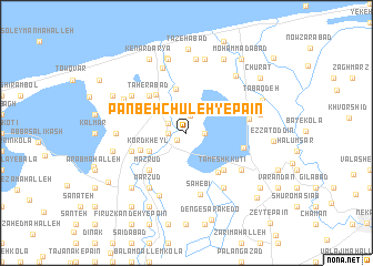
Panbeh Chūleh-ye Pā'īn (Iran)Panbeh Chūleh-ye Pā'īn is a town in Iran. An overview map of the region around Panbeh Chūleh-ye Pā'īn is displayed below.
regional and 3d topo map of Panbeh Chūleh-ye Pā'īn, Iran ::
Panbeh Chūleh-ye Pā'īn airports ::
The nearest airport is THR - Teheran Mehrabad Intl, located 200.5 km south west of Panbeh Chūleh-ye Pā'īn.
Nearby towns ::
Panbeh Chūleh-ye Bālā (1.0km south west) //
Mūzī Bāgh (1.8km north) //
Esfandān-e Bālā (1.5km west) //
Qājār Kheyl (1.5km east) //
Esfandān-e Pā'īn (1.8km north west) //
Kord Kheyl (3.5km south west) //
Sūteh (4.5km north) //
Ābmāl (4.1km south west) //
Ḩamīdābād (4.6km north west) //
Sūr Bon (4.7km south east) //
Mazrūd (4.8km south west) //
Tameshk Kūtī (4.8km south east) //
Ţāherābād (4.7km north west) //
Ākand (4.8km south west) //
Chefteh Sar (4.8km south west) //
Anār od Dīn (4.8km east) //
Şāḩebī (6.3km south) //
Dūl Marz (5.2km east) //
Dūl Marz (5.2km east) //
Marzūd (6.3km south west) //
Malīch Goleh (5.8km south east) //
Barār Deh (6.3km south east) //
Eslāmdeh-e Pā'īn (5.8km north west) //
Qādī Kolā (6.7km south) //
Faraḩābād (6.8km north) //
Dāzmīr Kandeh (5.7km west) //
Eslāmdeh-e Bālā (6.1km north west) //
Qāsemābād (7.4km north) //
Derāzmīr Kandeh (6.2km west) //
[all distances 'as the bird flies' and approximate]  Places with similar names to Panbeh Chūleh-ye Pā'īn, Iran :: Disclaimer :: Information on this page comes without warranty of any kind |
||
|
Where is Panbeh Chūleh-ye Pā'īn? Elevation and coordinates ::
Latitude (lat): 36°44'0"N Longitude (lon): 53°8'0"E
Elevation (approx.): -15m (map arrows pan, magnifying glasses zoom) |
||
|
Visiting Panbeh Chūleh-ye Pā'īn? Hotel/Accommodation ::
Book a hotel in Panbeh Chūleh-ye Pā'īn Travel Guide ::
Buy a travel guide for Iran rental cars ::
car rental offers GPS waypoint ::
download a GPX waypoint (PoI) of Panbeh Chūleh-ye Pā'īn for your GPS receiver
|
||