|
search place name
|
||
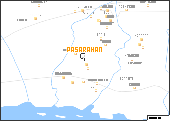
Pā Sarāhān (Hormozgān, Iran)Pā Sarāhān is a town in the Hormozgān region of Iran. An overview map of the region around Pā Sarāhān is displayed below.
regional and 3d topo map of Pā Sarāhān, Iran ::
Pā Sarāhān airports ::
The nearest airport is BND - Bandar Abbass Intl, located 26.4 km west of Pā Sarāhān.
Other airports nearby include KHS - Khasab (127.2 km south), RKT - Ras Al Khaimah Intl (195.5 km south), BDH - Bandar Lengeh (197.6 km south west), SHJ - Sharjah Intl (241.7 km south west), Nearby towns ::
Meshkī (1.0km south) //
Mehrīchī (1.9km south) //
Bābā ‘Ālem-e Pā'īn (2.3km north west) //
Tomūn-e Mashhadī Shahū (2.4km south west) //
Kūlaqān (4.8km south) //
Kūlaqān-e Kūchek (5.4km south west) //
Ţāherī (5.3km north east) //
Tomūn-e Malek (5.7km south east) //
Bārīz (5.7km north east) //
Ḩājjīābād (5.6km south west) //
Arzenī (7.1km south) //
Nowbast (8.5km north east) //
Sarjīn (9.2km north) //
Sarchīl Jalābī (9.2km north) //
Rīgū (10.2km north east) //
[all distances 'as the bird flies' and approximate] 
Disclaimer :: Information on this page comes without warranty of any kind |
||
|
Where is Pā Sarāhān? Elevation and coordinates ::
Latitude (lat): 27°15'41"N Longitude (lon): 56°38'25"E
Elevation (approx.): 11m (map arrows pan, magnifying glasses zoom) |
||
|
Visiting Pā Sarāhān? Hotel/Accommodation ::
Book a hotel in Pā Sarāhān Travel Guide ::
Buy a travel guide for Iran rental cars ::
car rental offers GPS waypoint ::
download a GPX waypoint (PoI) of Pā Sarāhān for your GPS receiver
|
||