|
search place name
|
||
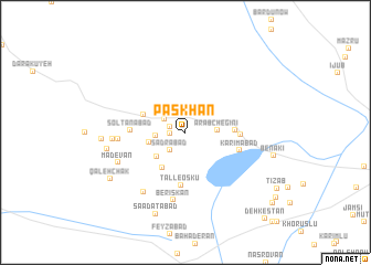
Pāskhan (Fārs, Iran)Pāskhan is a town in the Fārs region of Iran. An overview map of the region around Pāskhan is displayed below.
regional and 3d topo map of Pāskhan, Iran ::
Pāskhan airports ::
The nearest airport is SYZ - Shiraz Shahid Dastghaib Intl, located 188.2 km north west of Pāskhan.
Nearby towns ::
Rashīdābād (1.4km west) //
Hādīābād (1.4km west) //
Şadrābād (2.3km south west) //
Ḩasanābād (2.3km north west) //
Ma‘sūmābād (2.6km west) //
‘Arab Chegīnī (2.8km east) //
Zeynābād (2.8km east) //
Esmā‘īlābād (3.5km south west) //
‘Alīābād (3.4km west) //
Dād ol Ḩasan (4.1km south west) //
Ḩoseynābād (4.2km north west) //
Manşūrī (4.4km east) //
Tall-e Oskū (5.4km south) //
Solţānābād (4.9km west) //
Javanān (4.9km east) //
Karīmābād (5.2km east) //
Şadrābād (6.0km west) //
Berīskān (6.9km south) //
Sākhtemān-e Moḩammad Khānī (7.1km south west) //
Naz̧arābād (6.5km west) //
Mādevān (6.7km south west) //
Tolombeh-ye Emāmzādeh Bālā (7.1km west) //
Mehdīābād (7.4km west) //
Sa‘ādatābād (8.6km south) //
Qal‘eh Chak (8.1km south west) //
Benakī (8.1km east) //
Barāb (10.5km south east) //
Dehkestān (11.2km south east) //
[all distances 'as the bird flies' and approximate] 
Disclaimer :: Information on this page comes without warranty of any kind |
||
|
Where is Pāskhan? Elevation and coordinates ::
Latitude (lat): 28°46'53"N Longitude (lon): 54°19'16"E
Elevation (approx.): 1079m (map arrows pan, magnifying glasses zoom) |
||
|
Visiting Pāskhan? Hotel/Accommodation ::
Book a hotel in Pāskhan Travel Guide ::
Buy a travel guide for Iran rental cars ::
car rental offers GPS waypoint ::
download a GPX waypoint (PoI) of Pāskhan for your GPS receiver
|
||